You are here: Home > Network List > TA - USArray Transportable Network (new EarthScope stations) Stations List
> Station U51A La Follette, TN, USA > Earthquake Result Viewer
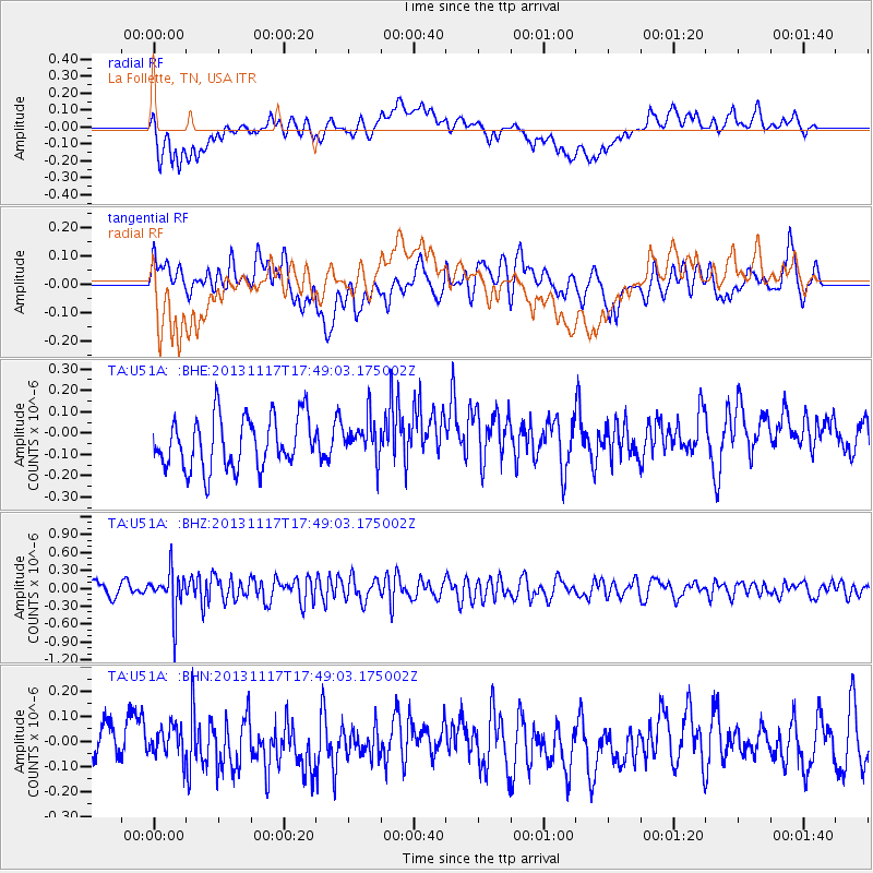
U51A La Follette, TN, USA - Earthquake Result Viewer
*The percent match for this event was below the threshold and hence no stack was calculated.
| Earthquake location: |
Ascension Island Region |
| Earthquake latitude/longitude: |
-10.3/-11.8 |
| Earthquake time(UTC): |
2013/11/17 (321) 17:37:14 GMT |
| Earthquake Depth: |
10 km |
| Earthquake Magnitude: |
5.5 MB, 5.4 MWC |
| Earthquake Catalog/Contributor: |
NEIC PDE/NEIC COMCAT |
|
| Network: |
TA USArray Transportable Network (new EarthScope stations) |
| Station: |
U51A La Follette, TN, USA |
| Lat/Lon: |
36.38 N/84.02 W |
| Elevation: |
472 m |
|
| Distance: |
82.1 deg |
| Az: |
309.131 deg |
| Baz: |
108.945 deg |
| Ray Param: |
$rayparam |
*The percent match for this event was below the threshold and hence was not used in the summary stack. |
|
| Radial Match: |
35.370617 % |
| Radial Bump: |
400 |
| Transverse Match: |
55.964363 % |
| Transverse Bump: |
400 |
| SOD ConfigId: |
626651 |
| Insert Time: |
2014-04-19 17:01:30.340 +0000 |
| GWidth: |
2.5 |
| Max Bumps: |
400 |
| Tol: |
0.001 |
|
Signal To Noise
| Channel | StoN | STA | LTA |
| TA:U51A: :BHZ:20131117T17:49:03.175002Z | 3.3022172 | 3.4329608E-7 | 1.0395927E-7 |
| TA:U51A: :BHN:20131117T17:49:03.175002Z | 0.7044196 | 5.7968933E-8 | 8.2293184E-8 |
| TA:U51A: :BHE:20131117T17:49:03.175002Z | 0.7729932 | 9.239792E-8 | 1.1953264E-7 |
| Arrivals |
| Ps | |
| PpPs | |
| PsPs/PpSs | |


