You are here: Home > Network List > TA - USArray Transportable Network (new EarthScope stations) Stations List
> Station W50A Signal Mountain, TN, USA > Earthquake Result Viewer
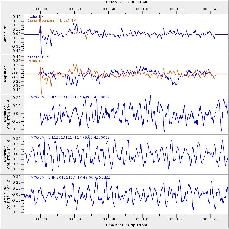
W50A Signal Mountain, TN, USA - Earthquake Result Viewer
*The percent match for this event was below the threshold and hence no stack was calculated.
| Earthquake location: |
Ascension Island Region |
| Earthquake latitude/longitude: |
-10.3/-11.8 |
| Earthquake time(UTC): |
2013/11/17 (321) 17:37:14 GMT |
| Earthquake Depth: |
10 km |
| Earthquake Magnitude: |
5.5 MB, 5.4 MWC |
| Earthquake Catalog/Contributor: |
NEIC PDE/NEIC COMCAT |
|
| Network: |
TA USArray Transportable Network (new EarthScope stations) |
| Station: |
W50A Signal Mountain, TN, USA |
| Lat/Lon: |
35.20 N/85.31 W |
| Elevation: |
587 m |
|
| Distance: |
82.7 deg |
| Az: |
307.669 deg |
| Baz: |
107.997 deg |
| Ray Param: |
$rayparam |
*The percent match for this event was below the threshold and hence was not used in the summary stack. |
|
| Radial Match: |
56.400967 % |
| Radial Bump: |
400 |
| Transverse Match: |
50.48849 % |
| Transverse Bump: |
400 |
| SOD ConfigId: |
626651 |
| Insert Time: |
2014-04-19 17:02:11.039 +0000 |
| GWidth: |
2.5 |
| Max Bumps: |
400 |
| Tol: |
0.001 |
|
Signal To Noise
| Channel | StoN | STA | LTA |
| TA:W50A: :BHZ:20131117T17:49:06.425002Z | 2.2666276 | 1.6293936E-7 | 7.188625E-8 |
| TA:W50A: :BHN:20131117T17:49:06.425002Z | 1.0802773 | 6.75596E-8 | 6.253912E-8 |
| TA:W50A: :BHE:20131117T17:49:06.425002Z | 1.6455567 | 1.0452197E-7 | 6.35177E-8 |
| Arrivals |
| Ps | |
| PpPs | |
| PsPs/PpSs | |


