You are here: Home > Network List > US - United States National Seismic Network Stations List
> Station ACSO Alum Creek State Park, Ohio, USA > Earthquake Result Viewer
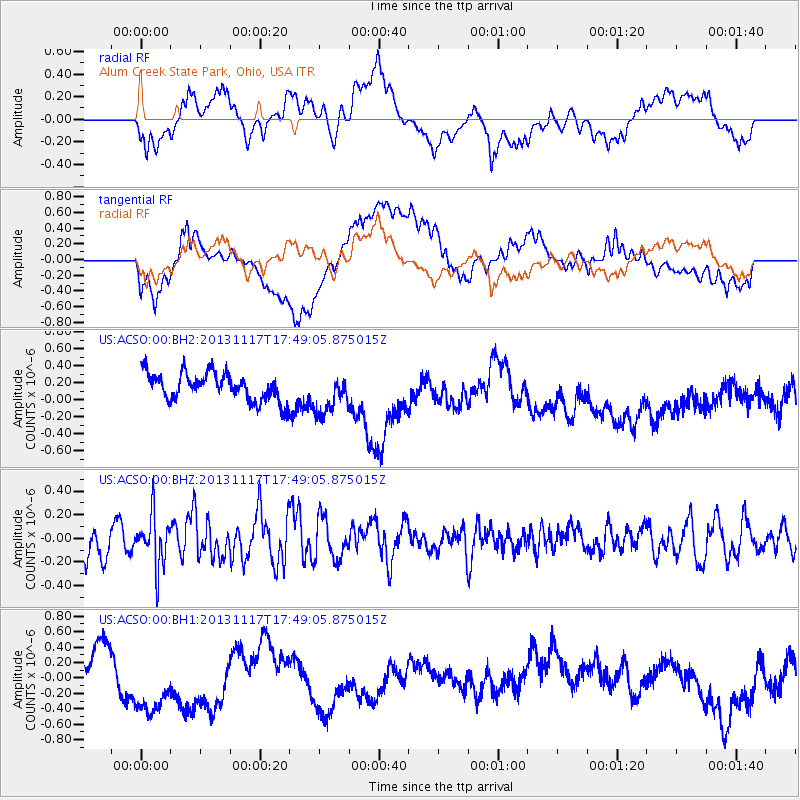
ACSO Alum Creek State Park, Ohio, USA - Earthquake Result Viewer
*The percent match for this event was below the threshold and hence no stack was calculated.
| Earthquake location: |
Ascension Island Region |
| Earthquake latitude/longitude: |
-10.3/-11.8 |
| Earthquake time(UTC): |
2013/11/17 (321) 17:37:14 GMT |
| Earthquake Depth: |
10 km |
| Earthquake Magnitude: |
5.5 MB, 5.4 MWC |
| Earthquake Catalog/Contributor: |
NEIC PDE/NEIC COMCAT |
|
| Network: |
US United States National Seismic Network |
| Station: |
ACSO Alum Creek State Park, Ohio, USA |
| Lat/Lon: |
40.23 N/82.98 W |
| Elevation: |
288 m |
|
| Distance: |
82.6 deg |
| Az: |
313.064 deg |
| Baz: |
110.109 deg |
| Ray Param: |
$rayparam |
*The percent match for this event was below the threshold and hence was not used in the summary stack. |
|
| Radial Match: |
55.96216 % |
| Radial Bump: |
400 |
| Transverse Match: |
39.71739 % |
| Transverse Bump: |
400 |
| SOD ConfigId: |
626651 |
| Insert Time: |
2014-04-19 17:03:26.349 +0000 |
| GWidth: |
2.5 |
| Max Bumps: |
400 |
| Tol: |
0.001 |
|
Signal To Noise
| Channel | StoN | STA | LTA |
| US:ACSO:00:BHZ:20131117T17:49:05.875015Z | 1.3006543 | 2.1402758E-7 | 1.6455378E-7 |
| US:ACSO:00:BH1:20131117T17:49:05.875015Z | 2.0928733 | 7.361443E-7 | 3.5173858E-7 |
| US:ACSO:00:BH2:20131117T17:49:05.875015Z | 1.4490122 | 2.3611311E-7 | 1.6294764E-7 |
| Arrivals |
| Ps | |
| PpPs | |
| PsPs/PpSs | |


