You are here: Home > Network List > TA - USArray Transportable Network (new EarthScope stations) Stations List
> Station G59A Clarenceville, QC, USA > Earthquake Result Viewer
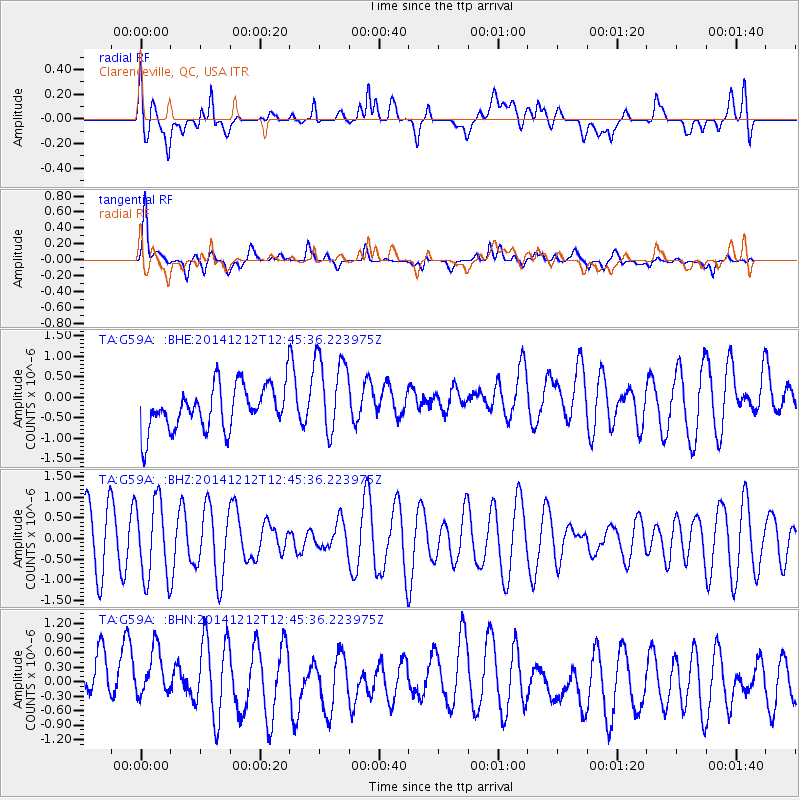
G59A Clarenceville, QC, USA - Earthquake Result Viewer
*The percent match for this event was below the threshold and hence no stack was calculated.
| Earthquake location: |
Near Coast Of Northern Chile |
| Earthquake latitude/longitude: |
-19.9/-70.9 |
| Earthquake time(UTC): |
2014/12/12 (346) 12:35:30 GMT |
| Earthquake Depth: |
20 km |
| Earthquake Magnitude: |
5.2 MW, 5.3 mb, 4.9 Ms_20, 5.1 Mwr, 5.1 Mww, 5.4 ML |
| Earthquake Catalog/Contributor: |
ISC/ISC |
|
| Network: |
TA USArray Transportable Network (new EarthScope stations) |
| Station: |
G59A Clarenceville, QC, USA |
| Lat/Lon: |
45.08 N/73.18 W |
| Elevation: |
36 m |
|
| Distance: |
64.7 deg |
| Az: |
358.236 deg |
| Baz: |
177.657 deg |
| Ray Param: |
$rayparam |
*The percent match for this event was below the threshold and hence was not used in the summary stack. |
|
| Radial Match: |
35.33245 % |
| Radial Bump: |
400 |
| Transverse Match: |
69.14815 % |
| Transverse Bump: |
400 |
| SOD ConfigId: |
3390531 |
| Insert Time: |
2019-04-15 12:58:52.519 +0000 |
| GWidth: |
2.5 |
| Max Bumps: |
400 |
| Tol: |
0.001 |
|
Signal To Noise
| Channel | StoN | STA | LTA |
| TA:G59A: :BHZ:20141212T12:45:36.223975Z | 1.2835705 | 9.590742E-7 | 7.471924E-7 |
| TA:G59A: :BHN:20141212T12:45:36.223975Z | 0.8759874 | 9.295276E-7 | 1.0611197E-6 |
| TA:G59A: :BHE:20141212T12:45:36.223975Z | 1.8947022 | 1.0177841E-6 | 5.3717366E-7 |
| Arrivals |
| Ps | |
| PpPs | |
| PsPs/PpSs | |


