You are here: Home > Network List > BK - Berkeley Digital Seismograph Network Stations List
> Station HUMO Hull Mountain, OR > Earthquake Result Viewer
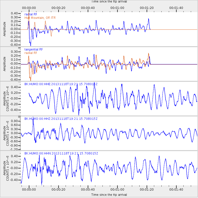
HUMO Hull Mountain, OR - Earthquake Result Viewer
*The percent match for this event was below the threshold and hence no stack was calculated.
| Earthquake location: |
Near S. Coast Of Honshu, Japan |
| Earthquake latitude/longitude: |
34.3/137.0 |
| Earthquake time(UTC): |
2013/11/18 (322) 19:10:45 GMT |
| Earthquake Depth: |
328 km |
| Earthquake Magnitude: |
5.6 MWW, 5.7 MWB, 5.7 MWC |
| Earthquake Catalog/Contributor: |
NEIC PDE/NEIC COMCAT |
|
| Network: |
BK Berkeley Digital Seismograph Network |
| Station: |
HUMO Hull Mountain, OR |
| Lat/Lon: |
42.61 N/122.96 W |
| Elevation: |
555 m |
|
| Distance: |
74.2 deg |
| Az: |
49.086 deg |
| Baz: |
302.108 deg |
| Ray Param: |
$rayparam |
*The percent match for this event was below the threshold and hence was not used in the summary stack. |
|
| Radial Match: |
62.73084 % |
| Radial Bump: |
400 |
| Transverse Match: |
56.63676 % |
| Transverse Bump: |
388 |
| SOD ConfigId: |
626651 |
| Insert Time: |
2014-04-19 17:12:10.548 +0000 |
| GWidth: |
2.5 |
| Max Bumps: |
400 |
| Tol: |
0.001 |
|
Signal To Noise
| Channel | StoN | STA | LTA |
| BK:HUMO:00:HHZ:20131118T19:21:15.708015Z | 2.650902 | 4.0693686E-7 | 1.5350882E-7 |
| BK:HUMO:00:HHN:20131118T19:21:15.708015Z | 0.81736284 | 1.4918432E-7 | 1.8251907E-7 |
| BK:HUMO:00:HHE:20131118T19:21:15.708015Z | 1.6219145 | 3.320199E-7 | 2.0470863E-7 |
| Arrivals |
| Ps | |
| PpPs | |
| PsPs/PpSs | |


