You are here: Home > Network List > CN - Canadian National Seismograph Network Stations List
> Station INK INUVIK, NT > Earthquake Result Viewer
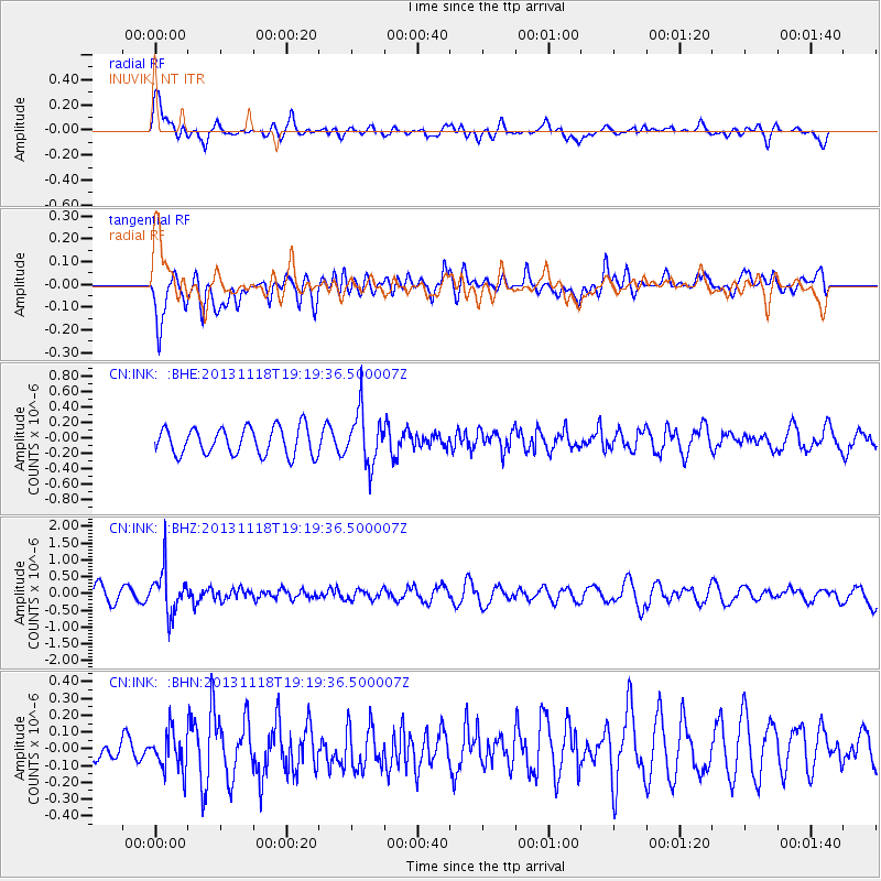
INK INUVIK, NT - Earthquake Result Viewer
*The percent match for this event was below the threshold and hence no stack was calculated.
| Earthquake location: |
Near S. Coast Of Honshu, Japan |
| Earthquake latitude/longitude: |
34.3/137.0 |
| Earthquake time(UTC): |
2013/11/18 (322) 19:10:45 GMT |
| Earthquake Depth: |
328 km |
| Earthquake Magnitude: |
5.6 MWW, 5.7 MWB, 5.7 MWC |
| Earthquake Catalog/Contributor: |
NEIC PDE/NEIC COMCAT |
|
| Network: |
CN Canadian National Seismograph Network |
| Station: |
INK INUVIK, NT |
| Lat/Lon: |
68.31 N/133.53 W |
| Elevation: |
44 m |
|
| Distance: |
58.4 deg |
| Az: |
25.886 deg |
| Baz: |
283.657 deg |
| Ray Param: |
$rayparam |
*The percent match for this event was below the threshold and hence was not used in the summary stack. |
|
| Radial Match: |
63.039738 % |
| Radial Bump: |
400 |
| Transverse Match: |
59.425583 % |
| Transverse Bump: |
400 |
| SOD ConfigId: |
626651 |
| Insert Time: |
2014-04-19 17:14:27.351 +0000 |
| GWidth: |
2.5 |
| Max Bumps: |
400 |
| Tol: |
0.001 |
|
Signal To Noise
| Channel | StoN | STA | LTA |
| CN:INK: :BHZ:20131118T19:19:36.500007Z | 2.789112 | 6.487541E-7 | 2.3260239E-7 |
| CN:INK: :BHN:20131118T19:19:36.500007Z | 0.92426205 | 1.1759463E-7 | 1.2723083E-7 |
| CN:INK: :BHE:20131118T19:19:36.500007Z | 1.9328177 | 3.419878E-7 | 1.7693743E-7 |
| Arrivals |
| Ps | |
| PpPs | |
| PsPs/PpSs | |


