You are here: Home > Network List > IU - Global Seismograph Network (GSN - IRIS/USGS) Stations List
> Station CTAO Charters Towers, Australia > Earthquake Result Viewer
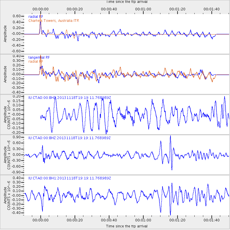
CTAO Charters Towers, Australia - Earthquake Result Viewer
*The percent match for this event was below the threshold and hence no stack was calculated.
| Earthquake location: |
Near S. Coast Of Honshu, Japan |
| Earthquake latitude/longitude: |
34.3/137.0 |
| Earthquake time(UTC): |
2013/11/18 (322) 19:10:45 GMT |
| Earthquake Depth: |
328 km |
| Earthquake Magnitude: |
5.6 MWW, 5.7 MWB, 5.7 MWC |
| Earthquake Catalog/Contributor: |
NEIC PDE/NEIC COMCAT |
|
| Network: |
IU Global Seismograph Network (GSN - IRIS/USGS) |
| Station: |
CTAO Charters Towers, Australia |
| Lat/Lon: |
20.09 S/146.25 E |
| Elevation: |
357 m |
|
| Distance: |
54.8 deg |
| Az: |
169.398 deg |
| Baz: |
350.678 deg |
| Ray Param: |
$rayparam |
*The percent match for this event was below the threshold and hence was not used in the summary stack. |
|
| Radial Match: |
62.107132 % |
| Radial Bump: |
400 |
| Transverse Match: |
45.16047 % |
| Transverse Bump: |
382 |
| SOD ConfigId: |
626651 |
| Insert Time: |
2014-04-19 17:18:45.664 +0000 |
| GWidth: |
2.5 |
| Max Bumps: |
400 |
| Tol: |
0.001 |
|
Signal To Noise
| Channel | StoN | STA | LTA |
| IU:CTAO:00:BHZ:20131118T19:19:11.768989Z | 2.4305873 | 1.9100192E-7 | 7.8582616E-8 |
| IU:CTAO:00:BH1:20131118T19:19:11.768989Z | 2.0912018 | 1.4215529E-7 | 6.7977794E-8 |
| IU:CTAO:00:BH2:20131118T19:19:11.768989Z | 1.583728 | 1.1655646E-7 | 7.359626E-8 |
| Arrivals |
| Ps | |
| PpPs | |
| PsPs/PpSs | |


