You are here: Home > Network List > IU - Global Seismograph Network (GSN - IRIS/USGS) Stations List
> Station PMG Port Moresby, New Guinea > Earthquake Result Viewer
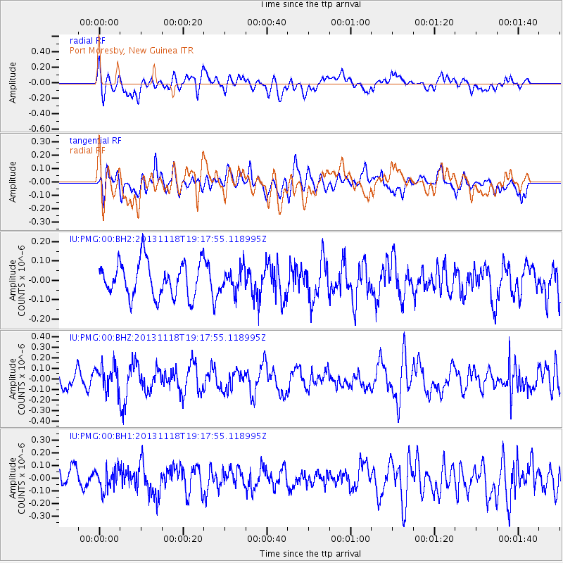
PMG Port Moresby, New Guinea - Earthquake Result Viewer
*The percent match for this event was below the threshold and hence no stack was calculated.
| Earthquake location: |
Near S. Coast Of Honshu, Japan |
| Earthquake latitude/longitude: |
34.3/137.0 |
| Earthquake time(UTC): |
2013/11/18 (322) 19:10:45 GMT |
| Earthquake Depth: |
328 km |
| Earthquake Magnitude: |
5.6 MWW, 5.7 MWB, 5.7 MWC |
| Earthquake Catalog/Contributor: |
NEIC PDE/NEIC COMCAT |
|
| Network: |
IU Global Seismograph Network (GSN - IRIS/USGS) |
| Station: |
PMG Port Moresby, New Guinea |
| Lat/Lon: |
9.40 S/147.16 E |
| Elevation: |
90 m |
|
| Distance: |
44.5 deg |
| Az: |
165.701 deg |
| Baz: |
348.046 deg |
| Ray Param: |
$rayparam |
*The percent match for this event was below the threshold and hence was not used in the summary stack. |
|
| Radial Match: |
55.248753 % |
| Radial Bump: |
400 |
| Transverse Match: |
52.34484 % |
| Transverse Bump: |
400 |
| SOD ConfigId: |
626651 |
| Insert Time: |
2014-04-19 17:19:06.169 +0000 |
| GWidth: |
2.5 |
| Max Bumps: |
400 |
| Tol: |
0.001 |
|
Signal To Noise
| Channel | StoN | STA | LTA |
| IU:PMG:00:BHZ:20131118T19:17:55.118995Z | 1.3248326 | 1.2044491E-7 | 9.091331E-8 |
| IU:PMG:00:BH1:20131118T19:17:55.118995Z | 1.3440903 | 8.618751E-8 | 6.41233E-8 |
| IU:PMG:00:BH2:20131118T19:17:55.118995Z | 0.6384778 | 5.7550643E-8 | 9.013727E-8 |
| Arrivals |
| Ps | |
| PpPs | |
| PsPs/PpSs | |


