You are here: Home > Network List > TA - USArray Transportable Network (new EarthScope stations) Stations List
> Station L04D Klamath Falls, OR, USA > Earthquake Result Viewer
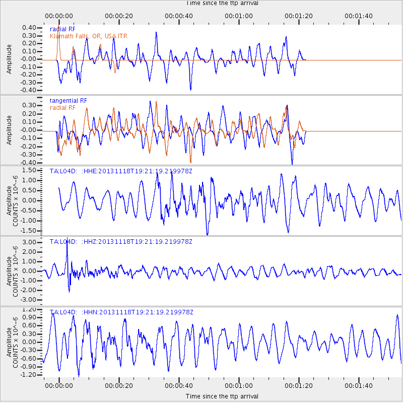
L04D Klamath Falls, OR, USA - Earthquake Result Viewer
*The percent match for this event was below the threshold and hence no stack was calculated.
| Earthquake location: |
Near S. Coast Of Honshu, Japan |
| Earthquake latitude/longitude: |
34.3/137.0 |
| Earthquake time(UTC): |
2013/11/18 (322) 19:10:45 GMT |
| Earthquake Depth: |
328 km |
| Earthquake Magnitude: |
5.6 MWW, 5.7 MWB, 5.7 MWC |
| Earthquake Catalog/Contributor: |
NEIC PDE/NEIC COMCAT |
|
| Network: |
TA USArray Transportable Network (new EarthScope stations) |
| Station: |
L04D Klamath Falls, OR, USA |
| Lat/Lon: |
42.22 N/122.30 W |
| Elevation: |
1437 m |
|
| Distance: |
74.8 deg |
| Az: |
49.159 deg |
| Baz: |
302.566 deg |
| Ray Param: |
$rayparam |
*The percent match for this event was below the threshold and hence was not used in the summary stack. |
|
| Radial Match: |
57.30994 % |
| Radial Bump: |
305 |
| Transverse Match: |
43.34418 % |
| Transverse Bump: |
334 |
| SOD ConfigId: |
626651 |
| Insert Time: |
2014-04-19 17:29:18.293 +0000 |
| GWidth: |
2.5 |
| Max Bumps: |
400 |
| Tol: |
0.001 |
|
Signal To Noise
| Channel | StoN | STA | LTA |
| TA:L04D: :HHZ:20131118T19:21:19.219978Z | 3.940588 | 1.001474E-6 | 2.5414326E-7 |
| TA:L04D: :HHN:20131118T19:21:19.219978Z | 0.9666734 | 5.6538454E-7 | 5.848765E-7 |
| TA:L04D: :HHE:20131118T19:21:19.219978Z | 1.7945851 | 7.7706113E-7 | 4.3300324E-7 |
| Arrivals |
| Ps | |
| PpPs | |
| PsPs/PpSs | |


