You are here: Home > Network List > TA - USArray Transportable Network (new EarthScope stations) Stations List
> Station MDND Maddock, ND, USA > Earthquake Result Viewer
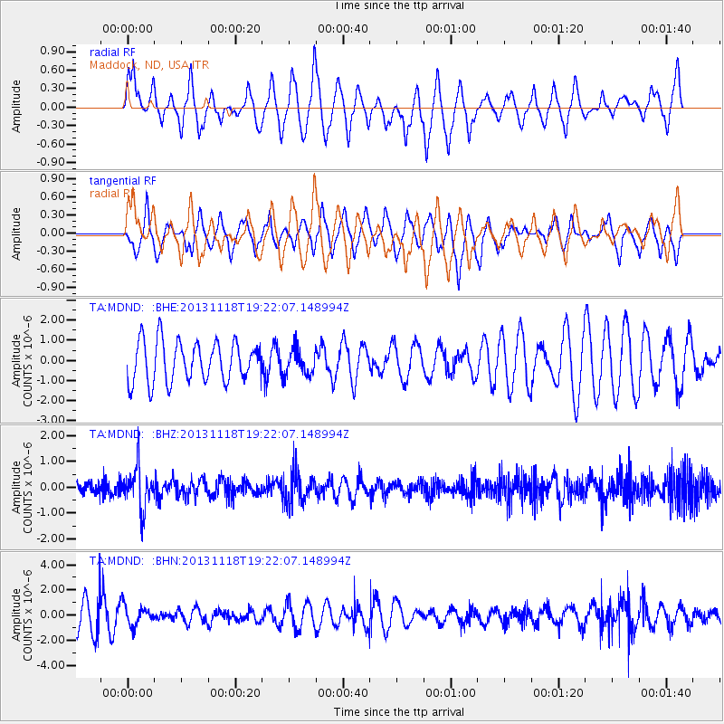
MDND Maddock, ND, USA - Earthquake Result Viewer
*The percent match for this event was below the threshold and hence no stack was calculated.
| Earthquake location: |
Near S. Coast Of Honshu, Japan |
| Earthquake latitude/longitude: |
34.3/137.0 |
| Earthquake time(UTC): |
2013/11/18 (322) 19:10:45 GMT |
| Earthquake Depth: |
328 km |
| Earthquake Magnitude: |
5.6 MWW, 5.7 MWB, 5.7 MWC |
| Earthquake Catalog/Contributor: |
NEIC PDE/NEIC COMCAT |
|
| Network: |
TA USArray Transportable Network (new EarthScope stations) |
| Station: |
MDND Maddock, ND, USA |
| Lat/Lon: |
47.85 N/99.60 W |
| Elevation: |
479 m |
|
| Distance: |
83.8 deg |
| Az: |
34.472 deg |
| Baz: |
315.944 deg |
| Ray Param: |
$rayparam |
*The percent match for this event was below the threshold and hence was not used in the summary stack. |
|
| Radial Match: |
49.632683 % |
| Radial Bump: |
348 |
| Transverse Match: |
64.40291 % |
| Transverse Bump: |
400 |
| SOD ConfigId: |
626651 |
| Insert Time: |
2014-04-19 17:29:49.017 +0000 |
| GWidth: |
2.5 |
| Max Bumps: |
400 |
| Tol: |
0.001 |
|
Signal To Noise
| Channel | StoN | STA | LTA |
| TA:MDND: :BHZ:20131118T19:22:07.148994Z | 3.8413596 | 8.017248E-7 | 2.087086E-7 |
| TA:MDND: :BHN:20131118T19:22:07.148994Z | 0.85393846 | 7.772329E-7 | 9.1017444E-7 |
| TA:MDND: :BHE:20131118T19:22:07.148994Z | 0.6381056 | 6.3983987E-7 | 1.0027179E-6 |
| Arrivals |
| Ps | |
| PpPs | |
| PsPs/PpSs | |


