You are here: Home > Network List > TA - USArray Transportable Network (new EarthScope stations) Stations List
> Station N47A Urbana, IN, USA > Earthquake Result Viewer
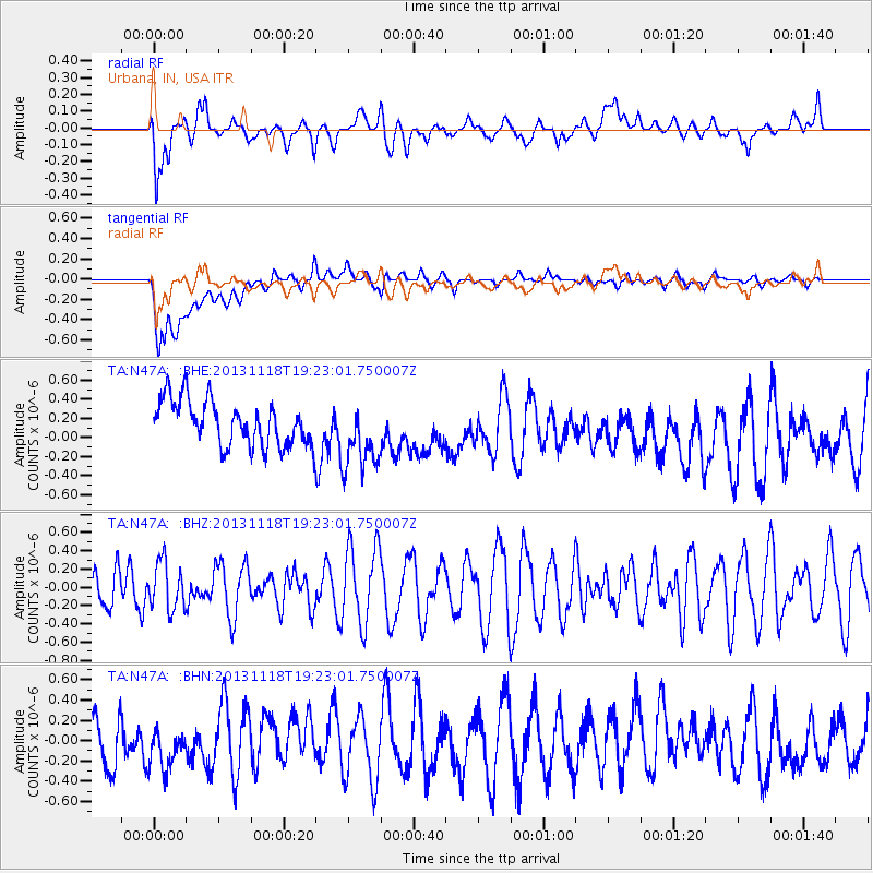
N47A Urbana, IN, USA - Earthquake Result Viewer
*The percent match for this event was below the threshold and hence no stack was calculated.
| Earthquake location: |
Near S. Coast Of Honshu, Japan |
| Earthquake latitude/longitude: |
34.3/137.0 |
| Earthquake time(UTC): |
2013/11/18 (322) 19:10:45 GMT |
| Earthquake Depth: |
328 km |
| Earthquake Magnitude: |
5.6 MWW, 5.7 MWB, 5.7 MWC |
| Earthquake Catalog/Contributor: |
NEIC PDE/NEIC COMCAT |
|
| Network: |
TA USArray Transportable Network (new EarthScope stations) |
| Station: |
N47A Urbana, IN, USA |
| Lat/Lon: |
40.88 N/85.69 W |
| Elevation: |
252 m |
|
| Distance: |
95.4 deg |
| Az: |
31.128 deg |
| Baz: |
325.655 deg |
| Ray Param: |
$rayparam |
*The percent match for this event was below the threshold and hence was not used in the summary stack. |
|
| Radial Match: |
61.95599 % |
| Radial Bump: |
400 |
| Transverse Match: |
48.911022 % |
| Transverse Bump: |
400 |
| SOD ConfigId: |
626651 |
| Insert Time: |
2014-04-19 17:29:59.064 +0000 |
| GWidth: |
2.5 |
| Max Bumps: |
400 |
| Tol: |
0.001 |
|
Signal To Noise
| Channel | StoN | STA | LTA |
| TA:N47A: :BHZ:20131118T19:23:01.750007Z | 1.1553315 | 2.5724873E-7 | 2.2266227E-7 |
| TA:N47A: :BHN:20131118T19:23:01.750007Z | 1.0671343 | 2.400054E-7 | 2.2490647E-7 |
| TA:N47A: :BHE:20131118T19:23:01.750007Z | 1.5339389 | 3.6501504E-7 | 2.3795933E-7 |
| Arrivals |
| Ps | |
| PpPs | |
| PsPs/PpSs | |


