You are here: Home > Network List > US - United States National Seismic Network Stations List
> Station NEW Newport, Washington, USA > Earthquake Result Viewer
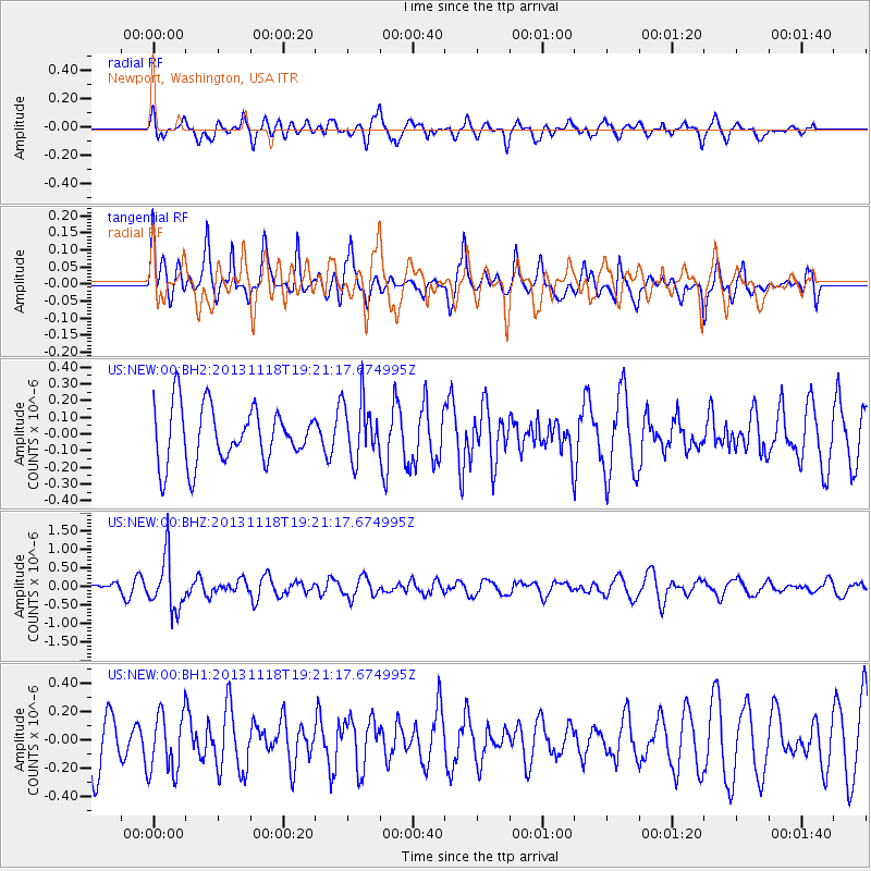
NEW Newport, Washington, USA - Earthquake Result Viewer
*The percent match for this event was below the threshold and hence no stack was calculated.
| Earthquake location: |
Near S. Coast Of Honshu, Japan |
| Earthquake latitude/longitude: |
34.3/137.0 |
| Earthquake time(UTC): |
2013/11/18 (322) 19:10:45 GMT |
| Earthquake Depth: |
328 km |
| Earthquake Magnitude: |
5.6 MWW, 5.7 MWB, 5.7 MWC |
| Earthquake Catalog/Contributor: |
NEIC PDE/NEIC COMCAT |
|
| Network: |
US United States National Seismic Network |
| Station: |
NEW Newport, Washington, USA |
| Lat/Lon: |
48.26 N/117.12 W |
| Elevation: |
760 m |
|
| Distance: |
74.5 deg |
| Az: |
41.838 deg |
| Baz: |
304.302 deg |
| Ray Param: |
$rayparam |
*The percent match for this event was below the threshold and hence was not used in the summary stack. |
|
| Radial Match: |
45.035427 % |
| Radial Bump: |
400 |
| Transverse Match: |
58.17058 % |
| Transverse Bump: |
400 |
| SOD ConfigId: |
626651 |
| Insert Time: |
2014-04-19 17:32:25.522 +0000 |
| GWidth: |
2.5 |
| Max Bumps: |
400 |
| Tol: |
0.001 |
|
Signal To Noise
| Channel | StoN | STA | LTA |
| US:NEW:00:BHZ:20131118T19:21:17.674995Z | 3.554339 | 7.0726975E-7 | 1.989877E-7 |
| US:NEW:00:BH1:20131118T19:21:17.674995Z | 1.5215335 | 2.1083612E-7 | 1.3856818E-7 |
| US:NEW:00:BH2:20131118T19:21:17.674995Z | 1.0502775 | 1.7514782E-7 | 1.6676339E-7 |
| Arrivals |
| Ps | |
| PpPs | |
| PsPs/PpSs | |


