You are here: Home > Network List > GO - National Seismic Network of Georgia Stations List
> Station TBLG Delisi, Georgia > Earthquake Result Viewer
TBLG Delisi, Georgia - Earthquake Result Viewer
| Earthquake location: |
Halmahera, Indonesia |
| Earthquake latitude/longitude: |
2.6/128.4 |
| Earthquake time(UTC): |
2013/11/19 (323) 13:32:51 GMT |
| Earthquake Depth: |
38 km |
| Earthquake Magnitude: |
6.0 MWW, 6.0 MWW, 6.0 MWC, 6.1 MWC, 6.1 MWB |
| Earthquake Catalog/Contributor: |
NEIC PDE/NEIC COMCAT |
|
| Network: |
GO National Seismic Network of Georgia |
| Station: |
TBLG Delisi, Georgia |
| Lat/Lon: |
41.73 N/44.74 E |
| Elevation: |
510 m |
|
| Distance: |
83.5 deg |
| Az: |
311.521 deg |
| Baz: |
92.22 deg |
| Ray Param: |
0.046057124 |
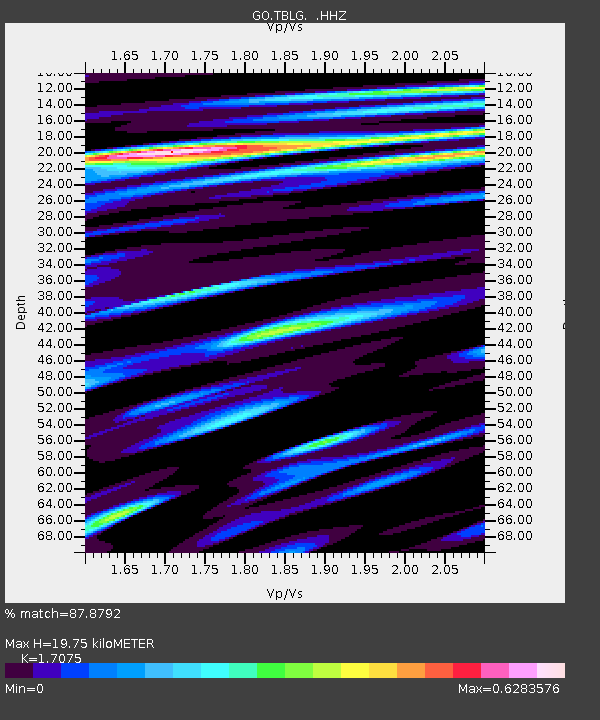
| Estimated Moho Depth: |
19.75 km |
| Estimated Crust Vp/Vs: |
1.71 |
| Assumed Crust Vp: |
6.291 km/s |
| Estimated Crust Vs: |
3.684 km/s |
| Estimated Crust Poisson's Ratio: |
0.24 |
|
| Radial Match: |
87.8792 % |
| Radial Bump: |
400 |
| Transverse Match: |
79.06029 % |
| Transverse Bump: |
400 |
| SOD ConfigId: |
626651 |
| Insert Time: |
2014-04-19 17:42:10.972 +0000 |
| GWidth: |
2.5 |
| Max Bumps: |
400 |
| Tol: |
0.001 |
|

Signal To Noise
| Channel | StoN | STA | LTA |
| GO:TBLG: :HHZ:20131119T13:44:44.149983Z | 10.595412 | 7.983995E-7 | 7.535333E-8 |
| GO:TBLG: :HHN:20131119T13:44:44.149983Z | 2.6009765 | 2.0832535E-7 | 8.009505E-8 |
| GO:TBLG: :HHE:20131119T13:44:44.149983Z | 1.9981904 | 2.3231348E-7 | 1.1626194E-7 |
| Arrivals |
| Ps | 2.3 SECOND |
| PpPs | 8.3 SECOND |
| PsPs/PpSs | 11 SECOND |


