You are here: Home > Network List > IC - New China Digital Seismograph Network Stations List
> Station WMQ Urumqi, Xinjiang Province, China > Earthquake Result Viewer
WMQ Urumqi, Xinjiang Province, China - Earthquake Result Viewer
| Earthquake location: |
Halmahera, Indonesia |
| Earthquake latitude/longitude: |
2.6/128.4 |
| Earthquake time(UTC): |
2013/11/19 (323) 13:32:51 GMT |
| Earthquake Depth: |
38 km |
| Earthquake Magnitude: |
6.0 MWW, 6.0 MWW, 6.0 MWC, 6.1 MWC, 6.1 MWB |
| Earthquake Catalog/Contributor: |
NEIC PDE/NEIC COMCAT |
|
| Network: |
IC New China Digital Seismograph Network |
| Station: |
WMQ Urumqi, Xinjiang Province, China |
| Lat/Lon: |
43.81 N/87.70 E |
| Elevation: |
850 m |
|
| Distance: |
54.6 deg |
| Az: |
324.576 deg |
| Baz: |
126.886 deg |
| Ray Param: |
0.065286346 |
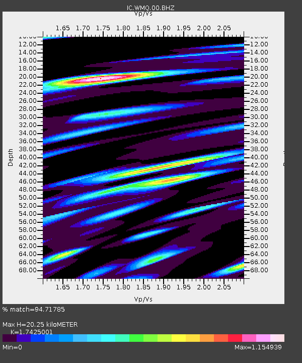
| Estimated Moho Depth: |
20.25 km |
| Estimated Crust Vp/Vs: |
1.74 |
| Assumed Crust Vp: |
6.242 km/s |
| Estimated Crust Vs: |
3.582 km/s |
| Estimated Crust Poisson's Ratio: |
0.25 |
|
| Radial Match: |
94.71785 % |
| Radial Bump: |
400 |
| Transverse Match: |
84.51916 % |
| Transverse Bump: |
400 |
| SOD ConfigId: |
626651 |
| Insert Time: |
2014-04-19 17:42:53.015 +0000 |
| GWidth: |
2.5 |
| Max Bumps: |
400 |
| Tol: |
0.001 |
|

Signal To Noise
| Channel | StoN | STA | LTA |
| IC:WMQ:00:BHZ:20131119T13:41:45.118977Z | 14.289198 | 1.7268708E-6 | 1.2085148E-7 |
| IC:WMQ:00:BH1:20131119T13:41:45.118977Z | 4.359306 | 5.059102E-7 | 1.16052924E-7 |
| IC:WMQ:00:BH2:20131119T13:41:45.118977Z | 6.0217924 | 5.343108E-7 | 8.872953E-8 |
| Arrivals |
| Ps | 2.5 SECOND |
| PpPs | 8.5 SECOND |
| PsPs/PpSs | 11 SECOND |


