You are here: Home > Network List > AK - Alaska Regional Network Stations List
> Station MDM Murphy Dome > Earthquake Result Viewer
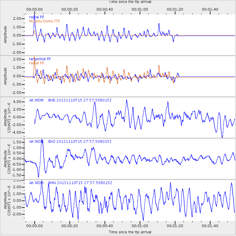
MDM Murphy Dome - Earthquake Result Viewer
*The percent match for this event was below the threshold and hence no stack was calculated.
| Earthquake location: |
W. Caroline Islands, Micronesia |
| Earthquake latitude/longitude: |
8.9/138.5 |
| Earthquake time(UTC): |
2013/11/19 (323) 15:16:48 GMT |
| Earthquake Depth: |
10 km |
| Earthquake Magnitude: |
5.9 MWW, 5.8 MWB, 6.0 MWC |
| Earthquake Catalog/Contributor: |
NEIC PDE/NEIC COMCAT |
|
| Network: |
AK Alaska Regional Network |
| Station: |
MDM Murphy Dome |
| Lat/Lon: |
64.96 N/148.23 W |
| Elevation: |
634 m |
|
| Distance: |
74.9 deg |
| Az: |
24.968 deg |
| Baz: |
258.508 deg |
| Ray Param: |
$rayparam |
*The percent match for this event was below the threshold and hence was not used in the summary stack. |
|
| Radial Match: |
76.11069 % |
| Radial Bump: |
330 |
| Transverse Match: |
64.32681 % |
| Transverse Bump: |
400 |
| SOD ConfigId: |
626651 |
| Insert Time: |
2014-04-19 17:49:02.836 +0000 |
| GWidth: |
2.5 |
| Max Bumps: |
400 |
| Tol: |
0.001 |
|
Signal To Noise
| Channel | StoN | STA | LTA |
| AK:MDM: :BHZ:20131119T15:27:57.568015Z | 5.260142 | 9.855063E-7 | 1.8735358E-7 |
| AK:MDM: :BHN:20131119T15:27:57.568015Z | 1.4343218 | 1.1763271E-6 | 8.2012775E-7 |
| AK:MDM: :BHE:20131119T15:27:57.568015Z | 3.0448742 | 2.1080382E-6 | 6.9232357E-7 |
| Arrivals |
| Ps | |
| PpPs | |
| PsPs/PpSs | |


