You are here: Home > Network List > AZ - ANZA Regional Network Stations List
> Station SCI2 San Clemente Island, CA, USA > Earthquake Result Viewer
SCI2 San Clemente Island, CA, USA - Earthquake Result Viewer
| Earthquake location: |
W. Caroline Islands, Micronesia |
| Earthquake latitude/longitude: |
8.9/138.5 |
| Earthquake time(UTC): |
2013/11/19 (323) 15:16:48 GMT |
| Earthquake Depth: |
10 km |
| Earthquake Magnitude: |
5.9 MWW, 5.8 MWB, 6.0 MWC |
| Earthquake Catalog/Contributor: |
NEIC PDE/NEIC COMCAT |
|
| Network: |
AZ ANZA Regional Network |
| Station: |
SCI2 San Clemente Island, CA, USA |
| Lat/Lon: |
32.92 N/118.49 W |
| Elevation: |
486 m |
|
| Distance: |
95.9 deg |
| Az: |
55.494 deg |
| Baz: |
284.528 deg |
| Ray Param: |
0.04065035 |
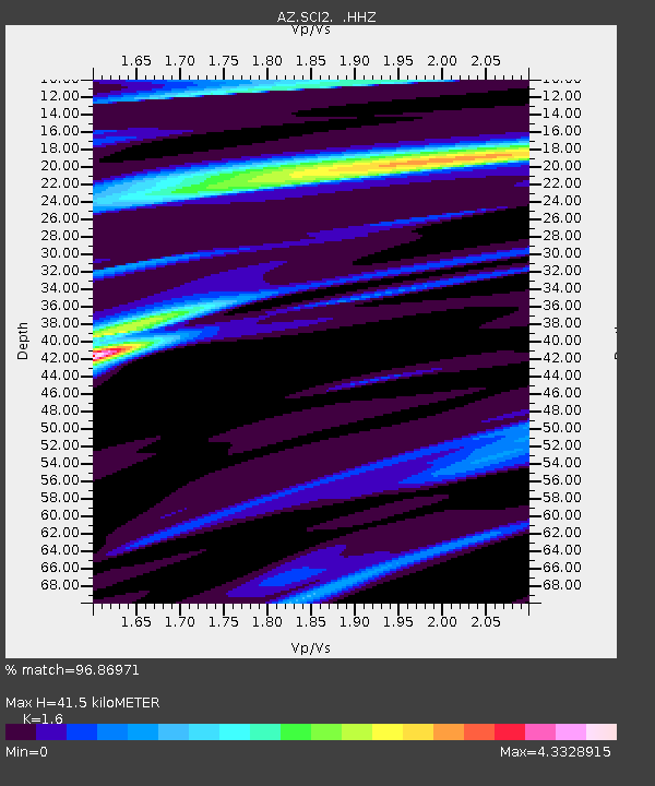
| Estimated Moho Depth: |
41.5 km |
| Estimated Crust Vp/Vs: |
1.60 |
| Assumed Crust Vp: |
6.048 km/s |
| Estimated Crust Vs: |
3.78 km/s |
| Estimated Crust Poisson's Ratio: |
0.18 |
|
| Radial Match: |
96.86971 % |
| Radial Bump: |
278 |
| Transverse Match: |
95.80716 % |
| Transverse Bump: |
267 |
| SOD ConfigId: |
626651 |
| Insert Time: |
2014-04-19 17:52:01.489 +0000 |
| GWidth: |
2.5 |
| Max Bumps: |
400 |
| Tol: |
0.001 |
|

Signal To Noise
| Channel | StoN | STA | LTA |
| AZ:SCI2: :HHZ:20131119T15:29:43.258018Z | 1.5089978 | 2.900928E-6 | 1.9224203E-6 |
| AZ:SCI2: :HHN:20131119T15:29:43.258018Z | 1.6541975 | 5.1472944E-6 | 3.1116567E-6 |
| AZ:SCI2: :HHE:20131119T15:29:43.258018Z | 1.4683735 | 8.540798E-6 | 5.816503E-6 |
| Arrivals |
| Ps | 4.2 SECOND |
| PpPs | 17 SECOND |
| PsPs/PpSs | 22 SECOND |


