You are here: Home > Network List > IC - New China Digital Seismograph Network Stations List
> Station WMQ Urumqi, Xinjiang Province, China > Earthquake Result Viewer
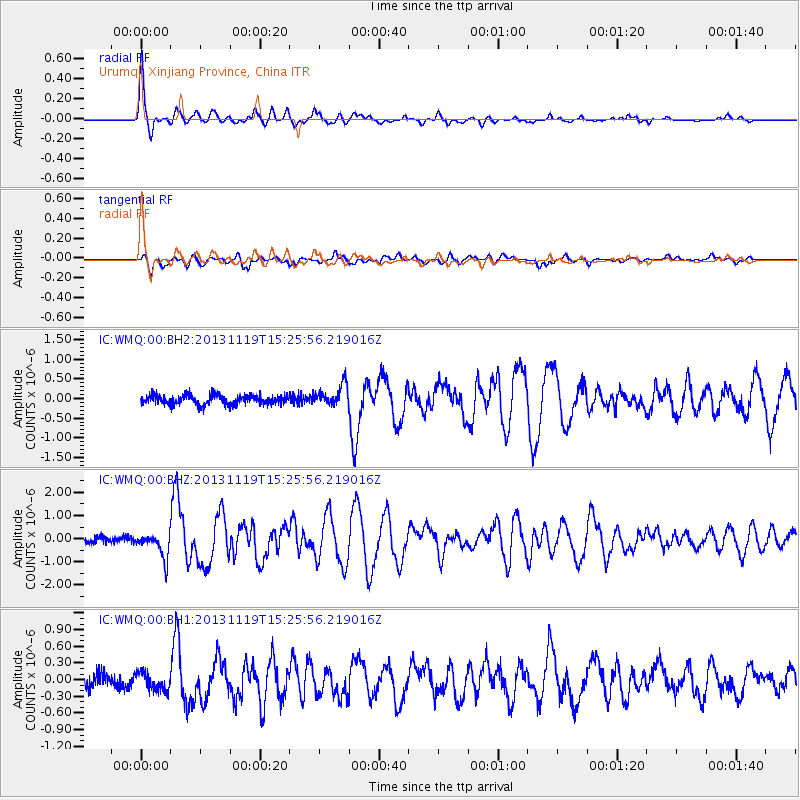
WMQ Urumqi, Xinjiang Province, China - Earthquake Result Viewer

| Earthquake location: |
W. Caroline Islands, Micronesia |
| Earthquake latitude/longitude: |
8.9/138.5 |
| Earthquake time(UTC): |
2013/11/19 (323) 15:16:48 GMT |
| Earthquake Depth: |
10 km |
| Earthquake Magnitude: |
5.9 MWW, 5.8 MWB, 6.0 MWC |
| Earthquake Catalog/Contributor: |
NEIC PDE/NEIC COMCAT |
|
| Network: |
IC New China Digital Seismograph Network |
| Station: |
WMQ Urumqi, Xinjiang Province, China |
| Lat/Lon: |
43.81 N/87.70 E |
| Elevation: |
850 m |
|
| Distance: |
56.1 deg |
| Az: |
317.445 deg |
| Baz: |
112.617 deg |
| Ray Param: |
0.06437423 |
| Estimated Moho Depth: |
43.25 km |
| Estimated Crust Vp/Vs: |
1.92 |
| Assumed Crust Vp: |
6.242 km/s |
| Estimated Crust Vs: |
3.255 km/s |
| Estimated Crust Poisson's Ratio: |
0.31 |
|
| Radial Match: |
94.879944 % |
| Radial Bump: |
341 |
| Transverse Match: |
80.36084 % |
| Transverse Bump: |
400 |
| SOD ConfigId: |
626651 |
| Insert Time: |
2014-04-19 17:56:10.738 +0000 |
| GWidth: |
2.5 |
| Max Bumps: |
400 |
| Tol: |
0.001 |
|
Signal To Noise
| Channel | StoN | STA | LTA |
| IC:WMQ:00:BHZ:20131119T15:25:56.219016Z | 4.603698 | 5.3992505E-7 | 1.17280734E-7 |
| IC:WMQ:00:BH1:20131119T15:25:56.219016Z | 1.5082434 | 1.5266667E-7 | 1.0122151E-7 |
| IC:WMQ:00:BH2:20131119T15:25:56.219016Z | 2.2762704 | 2.7347724E-7 | 1.201427E-7 |
| Arrivals |
| Ps | 6.6 SECOND |
| PpPs | 19 SECOND |
| PsPs/PpSs | 26 SECOND |


