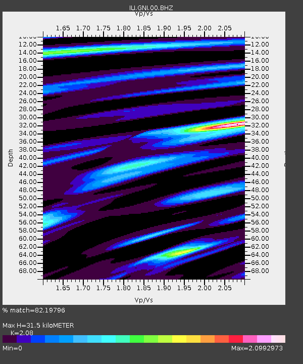
GNI Garni, Armenia - Earthquake Result Viewer
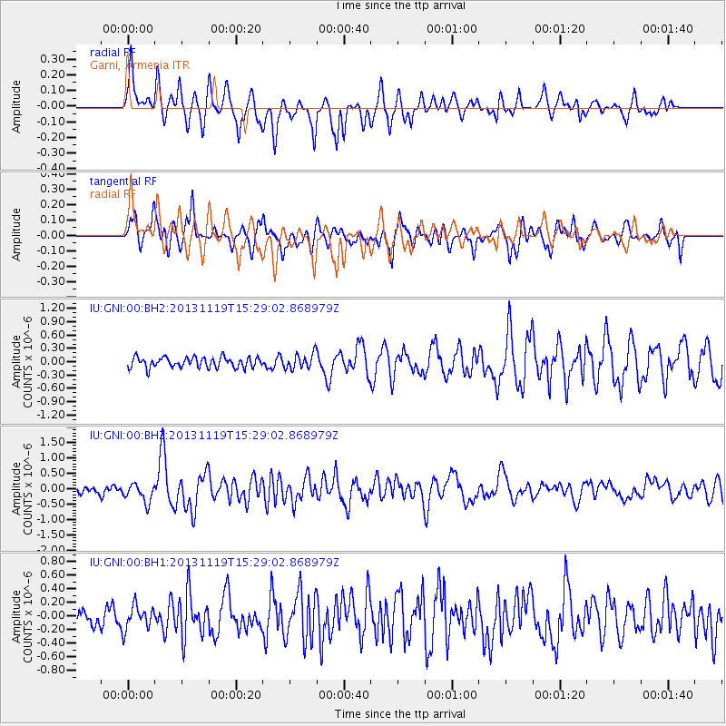
Earthquake location: W. Caroline Islands, Micronesia
Earthquake latitude/longitude: 8.9/138.5
Earthquake time(UTC): 2013/11/19 (323) 15:16:48 GMT
Earthquake Depth: 10 km
Earthquake Magnitude: 5.9 MWW, 5.8 MWB, 6.0 MWC
Earthquake Catalog/Contributor: NEIC PDE/NEIC COMCAT
Network: IU Global Seismograph Network (GSN - IRIS/USGS)
Station: GNI Garni, Armenia
Lat/Lon: 40.15 N/44.74 E
Elevation: 1609 m
Distance: 87.2 deg
Az: 310.027 deg
Baz: 80.784 deg
Ray Param: 0.04349182
Estimated Moho Depth: 31.5 km
Estimated Crust Vp/Vs: 2.08
Assumed Crust Vp: 6.291 km/s
Estimated Crust Vs: 3.024 km/s
Estimated Crust Poisson's Ratio: 0.35
Radial Match: 82.19796 %
Radial Bump: 400
Transverse Match: 67.50434 %
Transverse Bump: 400
SOD ConfigId: 626651
Insert Time: 2014-04-19 17:57:29.394 +0000
GWidth: 2.5
Max Bumps: 400
Tol: 0.001

Signal To Noise

ChannelStoNSTALTA
IU:GNI:00:BHZ:20131119T15:29:02.868979Z4.6658223.0154348E-76.462816E-8
IU:GNI:00:BH1:20131119T15:29:02.868979Z1.50846341.738347E-71.15239594E-7
IU:GNI:00:BH2:20131119T15:29:02.868979Z1.49978831.7325668E-71.1552076E-7
Arrivals
Ps5.5 SECOND
PpPs15 SECOND
PsPs/PpSs21 SECOND