You are here: Home > Network List > IW - Intermountain West Stations List
> Station DLMT Dillon, Montana, USA > Earthquake Result Viewer
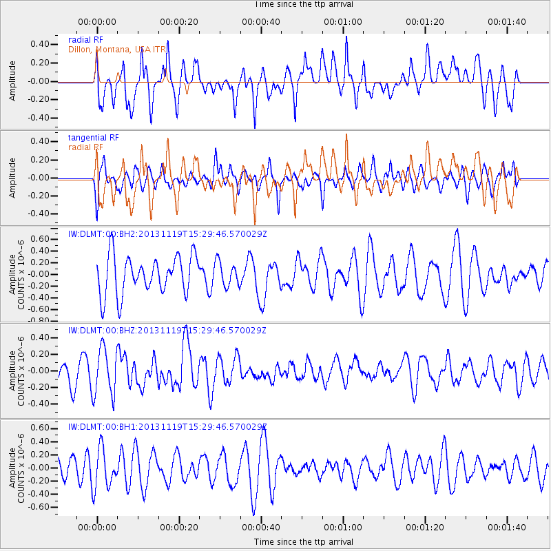
DLMT Dillon, Montana, USA - Earthquake Result Viewer
*The percent match for this event was below the threshold and hence no stack was calculated.
| Earthquake location: |
W. Caroline Islands, Micronesia |
| Earthquake latitude/longitude: |
8.9/138.5 |
| Earthquake time(UTC): |
2013/11/19 (323) 15:16:48 GMT |
| Earthquake Depth: |
10 km |
| Earthquake Magnitude: |
5.9 MWW, 5.8 MWB, 6.0 MWC |
| Earthquake Catalog/Contributor: |
NEIC PDE/NEIC COMCAT |
|
| Network: |
IW Intermountain West |
| Station: |
DLMT Dillon, Montana, USA |
| Lat/Lon: |
45.36 N/112.60 W |
| Elevation: |
1569 m |
|
| Distance: |
96.7 deg |
| Az: |
42.195 deg |
| Baz: |
289.722 deg |
| Ray Param: |
$rayparam |
*The percent match for this event was below the threshold and hence was not used in the summary stack. |
|
| Radial Match: |
70.33276 % |
| Radial Bump: |
400 |
| Transverse Match: |
36.837204 % |
| Transverse Bump: |
373 |
| SOD ConfigId: |
626651 |
| Insert Time: |
2014-04-19 17:57:39.305 +0000 |
| GWidth: |
2.5 |
| Max Bumps: |
400 |
| Tol: |
0.001 |
|
Signal To Noise
| Channel | StoN | STA | LTA |
| IW:DLMT:00:BHZ:20131119T15:29:46.570029Z | 2.7894514 | 2.8605814E-7 | 1.0254996E-7 |
| IW:DLMT:00:BH1:20131119T15:29:46.570029Z | 1.9227238 | 3.013075E-7 | 1.5670868E-7 |
| IW:DLMT:00:BH2:20131119T15:29:46.570029Z | 0.6196809 | 2.0493256E-7 | 3.3070663E-7 |
| Arrivals |
| Ps | |
| PpPs | |
| PsPs/PpSs | |


