You are here: Home > Network List > TA - USArray Transportable Network (new EarthScope stations) Stations List
> Station L04D Klamath Falls, OR, USA > Earthquake Result Viewer
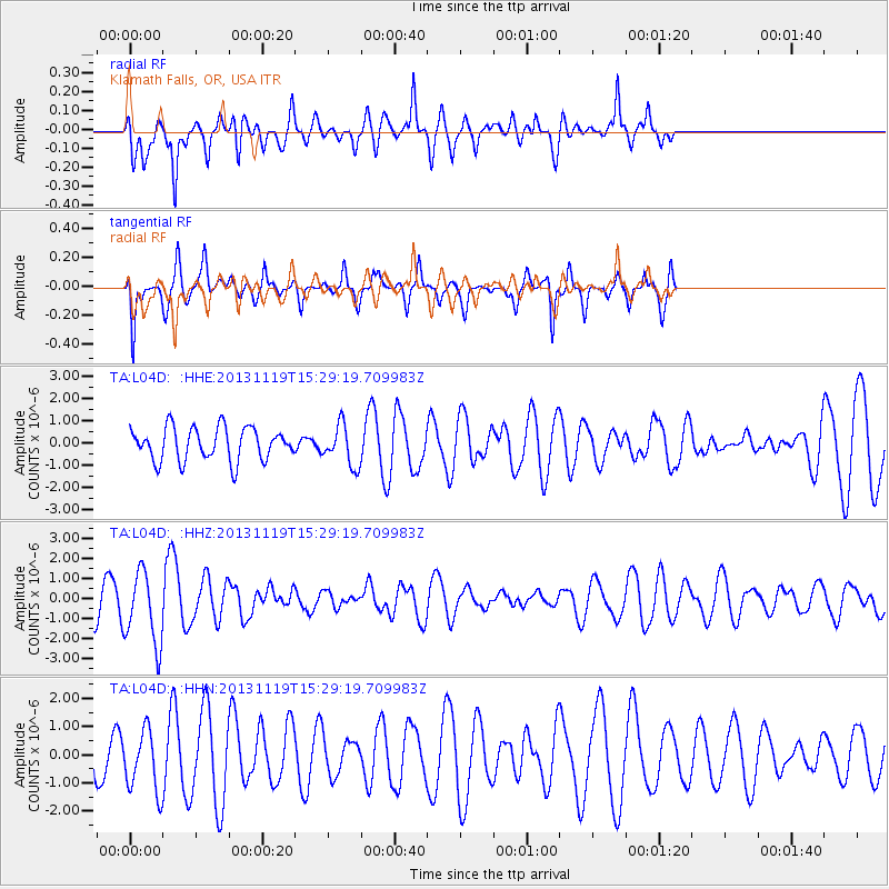
L04D Klamath Falls, OR, USA - Earthquake Result Viewer
*The percent match for this event was below the threshold and hence no stack was calculated.
| Earthquake location: |
W. Caroline Islands, Micronesia |
| Earthquake latitude/longitude: |
8.9/138.5 |
| Earthquake time(UTC): |
2013/11/19 (323) 15:16:48 GMT |
| Earthquake Depth: |
10 km |
| Earthquake Magnitude: |
5.9 MWW, 5.8 MWB, 6.0 MWC |
| Earthquake Catalog/Contributor: |
NEIC PDE/NEIC COMCAT |
|
| Network: |
TA USArray Transportable Network (new EarthScope stations) |
| Station: |
L04D Klamath Falls, OR, USA |
| Lat/Lon: |
42.22 N/122.30 W |
| Elevation: |
1437 m |
|
| Distance: |
90.8 deg |
| Az: |
47.174 deg |
| Baz: |
282.692 deg |
| Ray Param: |
$rayparam |
*The percent match for this event was below the threshold and hence was not used in the summary stack. |
|
| Radial Match: |
58.297787 % |
| Radial Bump: |
347 |
| Transverse Match: |
61.055195 % |
| Transverse Bump: |
287 |
| SOD ConfigId: |
626651 |
| Insert Time: |
2014-04-19 18:01:17.326 +0000 |
| GWidth: |
2.5 |
| Max Bumps: |
400 |
| Tol: |
0.001 |
|
Signal To Noise
| Channel | StoN | STA | LTA |
| TA:L04D: :HHZ:20131119T15:29:19.709983Z | 2.5799658 | 1.837091E-6 | 7.1206017E-7 |
| TA:L04D: :HHN:20131119T15:29:19.709983Z | 1.5266594 | 1.108934E-6 | 7.263795E-7 |
| TA:L04D: :HHE:20131119T15:29:19.709983Z | 1.2382337 | 9.1850626E-7 | 7.4178746E-7 |
| Arrivals |
| Ps | |
| PpPs | |
| PsPs/PpSs | |


