You are here: Home > Network List > TA - USArray Transportable Network (new EarthScope stations) Stations List
> Station H17A Grant Village (NPS), Yellowstone Nt. Park, WY, USA > Earthquake Result Viewer
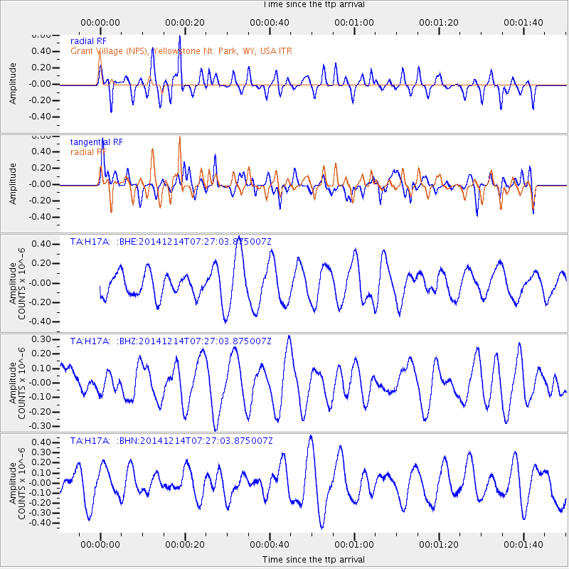
H17A Grant Village (NPS), Yellowstone Nt. Park, WY, USA - Earthquake Result Viewer
*The percent match for this event was below the threshold and hence no stack was calculated.
| Earthquake location: |
Kermadec Islands, New Zealand |
| Earthquake latitude/longitude: |
-30.6/-178.1 |
| Earthquake time(UTC): |
2014/12/14 (348) 07:14:08 GMT |
| Earthquake Depth: |
35 km |
| Earthquake Magnitude: |
5.2 MW, 5.2 mb |
| Earthquake Catalog/Contributor: |
ISC/ISC |
|
| Network: |
TA USArray Transportable Network (new EarthScope stations) |
| Station: |
H17A Grant Village (NPS), Yellowstone Nt. Park, WY, USA |
| Lat/Lon: |
44.40 N/110.58 W |
| Elevation: |
2400 m |
|
| Distance: |
96.7 deg |
| Az: |
41.832 deg |
| Baz: |
233.379 deg |
| Ray Param: |
$rayparam |
*The percent match for this event was below the threshold and hence was not used in the summary stack. |
|
| Radial Match: |
75.63686 % |
| Radial Bump: |
400 |
| Transverse Match: |
64.18326 % |
| Transverse Bump: |
400 |
| SOD ConfigId: |
3390531 |
| Insert Time: |
2019-04-15 13:36:18.404 +0000 |
| GWidth: |
2.5 |
| Max Bumps: |
400 |
| Tol: |
0.001 |
|
Signal To Noise
| Channel | StoN | STA | LTA |
| TA:H17A: :BHZ:20141214T07:27:03.875007Z | 0.43785492 | 5.9467176E-8 | 1.358148E-7 |
| TA:H17A: :BHN:20141214T07:27:03.875007Z | 1.0745059 | 1.367415E-7 | 1.2725988E-7 |
| TA:H17A: :BHE:20141214T07:27:03.875007Z | 2.7963762 | 3.124408E-7 | 1.117306E-7 |
| Arrivals |
| Ps | |
| PpPs | |
| PsPs/PpSs | |


