You are here: Home > Network List > BK - Berkeley Digital Seismograph Network Stations List
> Station HUMO Hull Mountain, OR > Earthquake Result Viewer
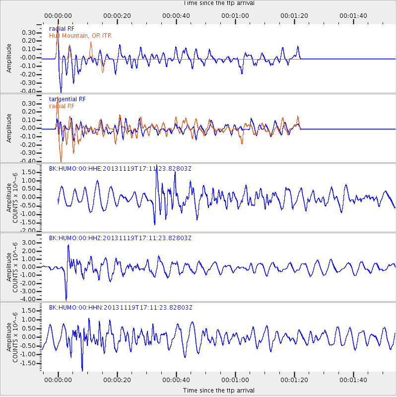
HUMO Hull Mountain, OR - Earthquake Result Viewer
*The percent match for this event was below the threshold and hence no stack was calculated.
| Earthquake location: |
Mariana Islands |
| Earthquake latitude/longitude: |
18.5/145.2 |
| Earthquake time(UTC): |
2013/11/19 (323) 17:00:44 GMT |
| Earthquake Depth: |
511 km |
| Earthquake Magnitude: |
6.0 MWW, 6.0 MWC, 6.0 MWB |
| Earthquake Catalog/Contributor: |
NEIC PDE/NEIC COMCAT |
|
| Network: |
BK Berkeley Digital Seismograph Network |
| Station: |
HUMO Hull Mountain, OR |
| Lat/Lon: |
42.61 N/122.96 W |
| Elevation: |
555 m |
|
| Distance: |
79.0 deg |
| Az: |
48.727 deg |
| Baz: |
284.939 deg |
| Ray Param: |
$rayparam |
*The percent match for this event was below the threshold and hence was not used in the summary stack. |
|
| Radial Match: |
75.53003 % |
| Radial Bump: |
400 |
| Transverse Match: |
31.132029 % |
| Transverse Bump: |
400 |
| SOD ConfigId: |
626651 |
| Insert Time: |
2014-04-19 18:09:42.014 +0000 |
| GWidth: |
2.5 |
| Max Bumps: |
400 |
| Tol: |
0.001 |
|
Signal To Noise
| Channel | StoN | STA | LTA |
| BK:HUMO:00:HHZ:20131119T17:11:23.82803Z | 4.5863934 | 1.3822838E-6 | 3.0138796E-7 |
| BK:HUMO:00:HHN:20131119T17:11:23.82803Z | 1.0597705 | 5.2984933E-7 | 4.999661E-7 |
| BK:HUMO:00:HHE:20131119T17:11:23.82803Z | 1.6266723 | 7.2244376E-7 | 4.441237E-7 |
| Arrivals |
| Ps | |
| PpPs | |
| PsPs/PpSs | |


