You are here: Home > Network List > CN - Canadian National Seismograph Network Stations List
> Station INK INUVIK, NT > Earthquake Result Viewer
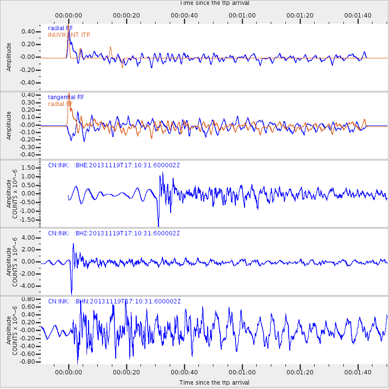
INK INUVIK, NT - Earthquake Result Viewer
*The percent match for this event was below the threshold and hence no stack was calculated.
| Earthquake location: |
Mariana Islands |
| Earthquake latitude/longitude: |
18.5/145.2 |
| Earthquake time(UTC): |
2013/11/19 (323) 17:00:44 GMT |
| Earthquake Depth: |
511 km |
| Earthquake Magnitude: |
6.0 MWW, 6.0 MWC, 6.0 MWB |
| Earthquake Catalog/Contributor: |
NEIC PDE/NEIC COMCAT |
|
| Network: |
CN Canadian National Seismograph Network |
| Station: |
INK INUVIK, NT |
| Lat/Lon: |
68.31 N/133.53 W |
| Elevation: |
44 m |
|
| Distance: |
69.8 deg |
| Az: |
23.058 deg |
| Baz: |
268.986 deg |
| Ray Param: |
$rayparam |
*The percent match for this event was below the threshold and hence was not used in the summary stack. |
|
| Radial Match: |
50.36582 % |
| Radial Bump: |
400 |
| Transverse Match: |
67.99706 % |
| Transverse Bump: |
400 |
| SOD ConfigId: |
626651 |
| Insert Time: |
2014-04-19 18:11:47.789 +0000 |
| GWidth: |
2.5 |
| Max Bumps: |
400 |
| Tol: |
0.001 |
|
Signal To Noise
| Channel | StoN | STA | LTA |
| CN:INK: :BHZ:20131119T17:10:31.600002Z | 7.473592 | 1.6278985E-6 | 2.178201E-7 |
| CN:INK: :BHN:20131119T17:10:31.600002Z | 0.9458303 | 2.660206E-7 | 2.8125615E-7 |
| CN:INK: :BHE:20131119T17:10:31.600002Z | 3.159684 | 6.5214175E-7 | 2.0639462E-7 |
| Arrivals |
| Ps | |
| PpPs | |
| PsPs/PpSs | |


