You are here: Home > Network List > TA - USArray Transportable Network (new EarthScope stations) Stations List
> Station POKR Poker Plat Research Range, AK, USA > Earthquake Result Viewer
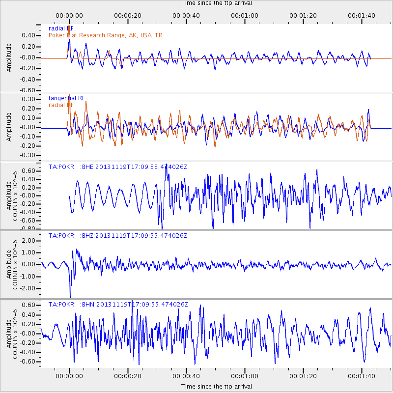
POKR Poker Plat Research Range, AK, USA - Earthquake Result Viewer
*The percent match for this event was below the threshold and hence no stack was calculated.
| Earthquake location: |
Mariana Islands |
| Earthquake latitude/longitude: |
18.5/145.2 |
| Earthquake time(UTC): |
2013/11/19 (323) 17:00:44 GMT |
| Earthquake Depth: |
511 km |
| Earthquake Magnitude: |
6.0 MWW, 6.0 MWC, 6.0 MWB |
| Earthquake Catalog/Contributor: |
NEIC PDE/NEIC COMCAT |
|
| Network: |
TA USArray Transportable Network (new EarthScope stations) |
| Station: |
POKR Poker Plat Research Range, AK, USA |
| Lat/Lon: |
65.12 N/147.43 W |
| Elevation: |
501 m |
|
| Distance: |
63.9 deg |
| Az: |
25.775 deg |
| Baz: |
257.28 deg |
| Ray Param: |
$rayparam |
*The percent match for this event was below the threshold and hence was not used in the summary stack. |
|
| Radial Match: |
64.70948 % |
| Radial Bump: |
400 |
| Transverse Match: |
58.420063 % |
| Transverse Bump: |
400 |
| SOD ConfigId: |
626651 |
| Insert Time: |
2014-04-19 18:21:53.520 +0000 |
| GWidth: |
2.5 |
| Max Bumps: |
400 |
| Tol: |
0.001 |
|
Signal To Noise
| Channel | StoN | STA | LTA |
| TA:POKR: :BHZ:20131119T17:09:55.474026Z | 6.3088326 | 9.858334E-7 | 1.562624E-7 |
| TA:POKR: :BHN:20131119T17:09:55.474026Z | 1.2722788 | 2.3206641E-7 | 1.8240216E-7 |
| TA:POKR: :BHE:20131119T17:09:55.474026Z | 2.0574992 | 4.3068954E-7 | 2.0932671E-7 |
| Arrivals |
| Ps | |
| PpPs | |
| PsPs/PpSs | |


