You are here: Home > Network List > UU - University of Utah Regional Network Stations List
> Station CCUT Cedar City, UT, USA > Earthquake Result Viewer
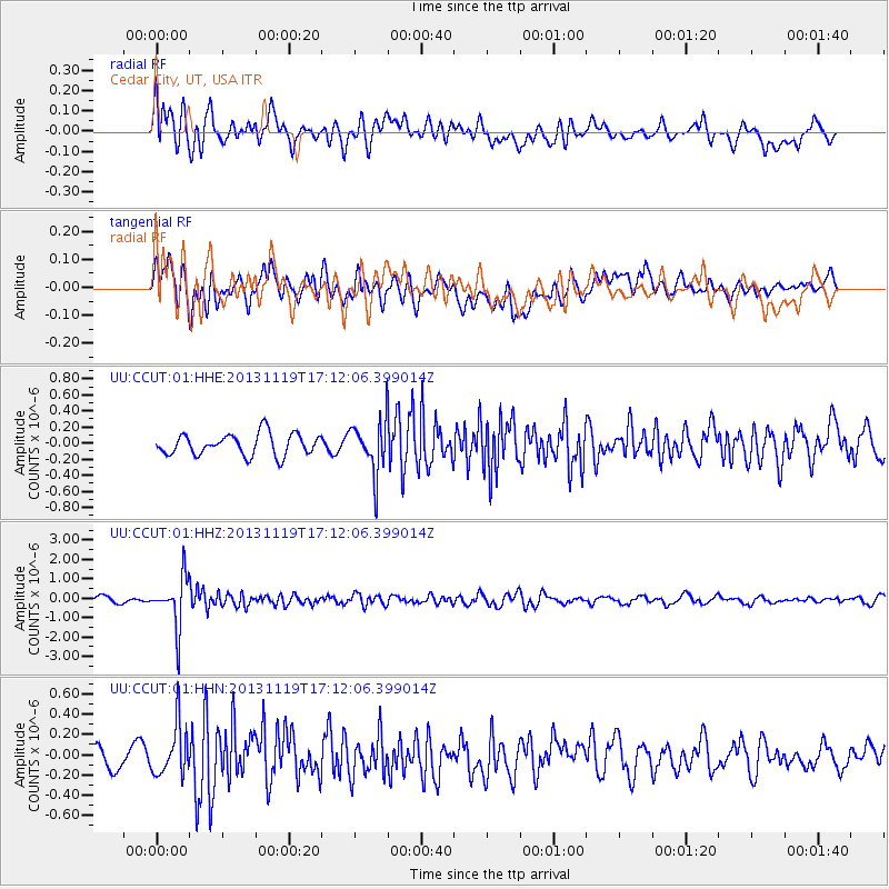
CCUT Cedar City, UT, USA - Earthquake Result Viewer
*The percent match for this event was below the threshold and hence no stack was calculated.
| Earthquake location: |
Mariana Islands |
| Earthquake latitude/longitude: |
18.5/145.2 |
| Earthquake time(UTC): |
2013/11/19 (323) 17:00:44 GMT |
| Earthquake Depth: |
511 km |
| Earthquake Magnitude: |
6.0 MWW, 6.0 MWC, 6.0 MWB |
| Earthquake Catalog/Contributor: |
NEIC PDE/NEIC COMCAT |
|
| Network: |
UU University of Utah Regional Network |
| Station: |
CCUT Cedar City, UT, USA |
| Lat/Lon: |
37.55 N/113.36 W |
| Elevation: |
2127 m |
|
| Distance: |
87.6 deg |
| Az: |
51.232 deg |
| Baz: |
291.398 deg |
| Ray Param: |
$rayparam |
*The percent match for this event was below the threshold and hence was not used in the summary stack. |
|
| Radial Match: |
66.057945 % |
| Radial Bump: |
400 |
| Transverse Match: |
60.85263 % |
| Transverse Bump: |
400 |
| SOD ConfigId: |
626651 |
| Insert Time: |
2014-04-19 18:23:34.913 +0000 |
| GWidth: |
2.5 |
| Max Bumps: |
400 |
| Tol: |
0.001 |
|
Signal To Noise
| Channel | StoN | STA | LTA |
| UU:CCUT:01:HHZ:20131119T17:12:06.399014Z | 10.353435 | 1.2853931E-6 | 1.2415137E-7 |
| UU:CCUT:01:HHN:20131119T17:12:06.399014Z | 2.297923 | 2.529583E-7 | 1.10081274E-7 |
| UU:CCUT:01:HHE:20131119T17:12:06.399014Z | 2.4064293 | 3.2149765E-7 | 1.3359947E-7 |
| Arrivals |
| Ps | |
| PpPs | |
| PsPs/PpSs | |


