You are here: Home > Network List > UW - Pacific Northwest Regional Seismic Network Stations List
> Station LCCR Mulino, OR, USA > Earthquake Result Viewer
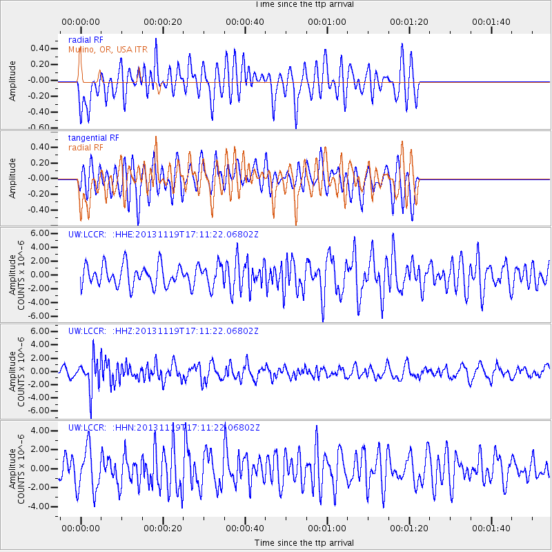
LCCR Mulino, OR, USA - Earthquake Result Viewer
*The percent match for this event was below the threshold and hence no stack was calculated.
| Earthquake location: |
Mariana Islands |
| Earthquake latitude/longitude: |
18.5/145.2 |
| Earthquake time(UTC): |
2013/11/19 (323) 17:00:44 GMT |
| Earthquake Depth: |
511 km |
| Earthquake Magnitude: |
6.0 MWW, 6.0 MWC, 6.0 MWB |
| Earthquake Catalog/Contributor: |
NEIC PDE/NEIC COMCAT |
|
| Network: |
UW Pacific Northwest Regional Seismic Network |
| Station: |
LCCR Mulino, OR, USA |
| Lat/Lon: |
45.21 N/122.48 W |
| Elevation: |
273 m |
|
| Distance: |
78.7 deg |
| Az: |
46.078 deg |
| Baz: |
284.758 deg |
| Ray Param: |
$rayparam |
*The percent match for this event was below the threshold and hence was not used in the summary stack. |
|
| Radial Match: |
56.43851 % |
| Radial Bump: |
400 |
| Transverse Match: |
54.335014 % |
| Transverse Bump: |
400 |
| SOD ConfigId: |
626651 |
| Insert Time: |
2014-04-19 18:24:59.577 +0000 |
| GWidth: |
2.5 |
| Max Bumps: |
400 |
| Tol: |
0.001 |
|
Signal To Noise
| Channel | StoN | STA | LTA |
| UW:LCCR: :HHZ:20131119T17:11:22.06802Z | 2.557748 | 2.254897E-6 | 8.8159464E-7 |
| UW:LCCR: :HHN:20131119T17:11:22.06802Z | 1.5185146 | 2.3409882E-6 | 1.5416302E-6 |
| UW:LCCR: :HHE:20131119T17:11:22.06802Z | 1.0416749 | 1.5773809E-6 | 1.5142738E-6 |
| Arrivals |
| Ps | |
| PpPs | |
| PsPs/PpSs | |


