You are here: Home > Network List > UW - Pacific Northwest Regional Seismic Network Stations List
> Station YACT Amboy, WA, USA > Earthquake Result Viewer
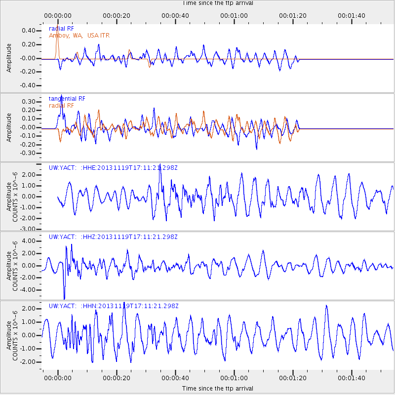
YACT Amboy, WA, USA - Earthquake Result Viewer
*The percent match for this event was below the threshold and hence no stack was calculated.
| Earthquake location: |
Mariana Islands |
| Earthquake latitude/longitude: |
18.5/145.2 |
| Earthquake time(UTC): |
2013/11/19 (323) 17:00:44 GMT |
| Earthquake Depth: |
511 km |
| Earthquake Magnitude: |
6.0 MWW, 6.0 MWC, 6.0 MWB |
| Earthquake Catalog/Contributor: |
NEIC PDE/NEIC COMCAT |
|
| Network: |
UW Pacific Northwest Regional Seismic Network |
| Station: |
YACT Amboy, WA, USA |
| Lat/Lon: |
45.93 N/122.42 W |
| Elevation: |
211 m |
|
| Distance: |
78.6 deg |
| Az: |
45.35 deg |
| Baz: |
284.657 deg |
| Ray Param: |
$rayparam |
*The percent match for this event was below the threshold and hence was not used in the summary stack. |
|
| Radial Match: |
55.9118 % |
| Radial Bump: |
342 |
| Transverse Match: |
77.372574 % |
| Transverse Bump: |
334 |
| SOD ConfigId: |
626651 |
| Insert Time: |
2014-04-19 18:25:32.439 +0000 |
| GWidth: |
2.5 |
| Max Bumps: |
400 |
| Tol: |
0.001 |
|
Signal To Noise
| Channel | StoN | STA | LTA |
| UW:YACT: :HHZ:20131119T17:11:21.298Z | 2.3620517 | 1.958137E-6 | 8.289984E-7 |
| UW:YACT: :HHN:20131119T17:11:21.298Z | 0.8587595 | 6.693297E-7 | 7.7941456E-7 |
| UW:YACT: :HHE:20131119T17:11:21.298Z | 1.6297686 | 1.1192983E-6 | 6.867836E-7 |
| Arrivals |
| Ps | |
| PpPs | |
| PsPs/PpSs | |


