You are here: Home > Network List > G - GEOSCOPE Stations List
> Station TAM Tamanrasset, Algeria > Earthquake Result Viewer
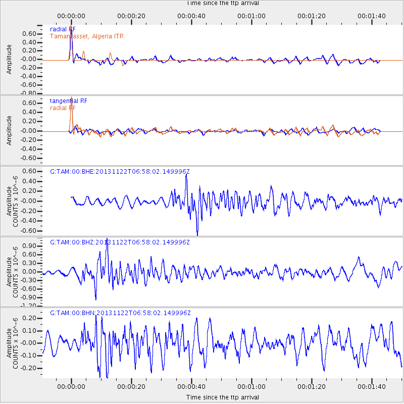
TAM Tamanrasset, Algeria - Earthquake Result Viewer
*The percent match for this event was below the threshold and hence no stack was calculated.
| Earthquake location: |
Iran-Iraq Border Region |
| Earthquake latitude/longitude: |
34.5/45.5 |
| Earthquake time(UTC): |
2013/11/22 (326) 06:51:25 GMT |
| Earthquake Depth: |
6.0 km |
| Earthquake Magnitude: |
5.6 MWB, 5.7 MWC |
| Earthquake Catalog/Contributor: |
NEIC PDE/NEIC COMCAT |
|
| Network: |
G GEOSCOPE |
| Station: |
TAM Tamanrasset, Algeria |
| Lat/Lon: |
22.79 N/5.53 E |
| Elevation: |
1377 m |
|
| Distance: |
36.7 deg |
| Az: |
262.298 deg |
| Baz: |
62.538 deg |
| Ray Param: |
$rayparam |
*The percent match for this event was below the threshold and hence was not used in the summary stack. |
|
| Radial Match: |
79.15255 % |
| Radial Bump: |
281 |
| Transverse Match: |
50.339813 % |
| Transverse Bump: |
345 |
| SOD ConfigId: |
626651 |
| Insert Time: |
2014-04-19 18:44:47.900 +0000 |
| GWidth: |
2.5 |
| Max Bumps: |
400 |
| Tol: |
0.001 |
|
Signal To Noise
| Channel | StoN | STA | LTA |
| G:TAM:00:BHZ:20131122T06:58:02.149996Z | 3.0711393 | 1.9322374E-7 | 6.291599E-8 |
| G:TAM:00:BHN:20131122T06:58:02.149996Z | 1.049187 | 5.65756E-8 | 5.3923284E-8 |
| G:TAM:00:BHE:20131122T06:58:02.149996Z | 1.5895531 | 1.0324194E-7 | 6.495029E-8 |
| Arrivals |
| Ps | |
| PpPs | |
| PsPs/PpSs | |


