You are here: Home > Network List > IC - New China Digital Seismograph Network Stations List
> Station KMI Kunming, Yunnan Province, China > Earthquake Result Viewer
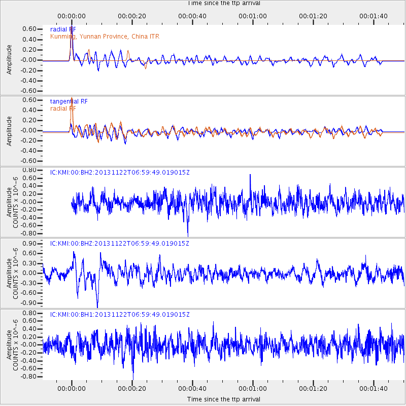
KMI Kunming, Yunnan Province, China - Earthquake Result Viewer
*The percent match for this event was below the threshold and hence no stack was calculated.
| Earthquake location: |
Iran-Iraq Border Region |
| Earthquake latitude/longitude: |
34.5/45.5 |
| Earthquake time(UTC): |
2013/11/22 (326) 06:51:25 GMT |
| Earthquake Depth: |
6.0 km |
| Earthquake Magnitude: |
5.6 MWB, 5.7 MWC |
| Earthquake Catalog/Contributor: |
NEIC PDE/NEIC COMCAT |
|
| Network: |
IC New China Digital Seismograph Network |
| Station: |
KMI Kunming, Yunnan Province, China |
| Lat/Lon: |
25.12 N/102.74 E |
| Elevation: |
1975 m |
|
| Distance: |
50.0 deg |
| Az: |
84.549 deg |
| Baz: |
294.847 deg |
| Ray Param: |
$rayparam |
*The percent match for this event was below the threshold and hence was not used in the summary stack. |
|
| Radial Match: |
75.15142 % |
| Radial Bump: |
400 |
| Transverse Match: |
65.05608 % |
| Transverse Bump: |
400 |
| SOD ConfigId: |
626651 |
| Insert Time: |
2014-04-19 18:45:45.756 +0000 |
| GWidth: |
2.5 |
| Max Bumps: |
400 |
| Tol: |
0.001 |
|
Signal To Noise
| Channel | StoN | STA | LTA |
| IC:KMI:00:BHZ:20131122T06:59:49.019015Z | 2.8840673 | 3.4694037E-7 | 1.2029552E-7 |
| IC:KMI:00:BH1:20131122T06:59:49.019015Z | 1.6408736 | 2.0794303E-7 | 1.2672703E-7 |
| IC:KMI:00:BH2:20131122T06:59:49.019015Z | 1.4346349 | 1.9564868E-7 | 1.3637523E-7 |
| Arrivals |
| Ps | |
| PpPs | |
| PsPs/PpSs | |


