You are here: Home > Network List > TA - USArray Transportable Network (new EarthScope stations) Stations List
> Station J62A Henniker, NH, USA > Earthquake Result Viewer
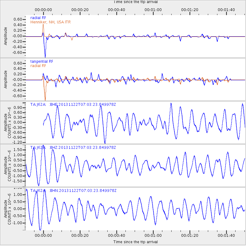
J62A Henniker, NH, USA - Earthquake Result Viewer
*The percent match for this event was below the threshold and hence no stack was calculated.
| Earthquake location: |
Iran-Iraq Border Region |
| Earthquake latitude/longitude: |
34.5/45.5 |
| Earthquake time(UTC): |
2013/11/22 (326) 06:51:25 GMT |
| Earthquake Depth: |
6.0 km |
| Earthquake Magnitude: |
5.6 MWB, 5.7 MWC |
| Earthquake Catalog/Contributor: |
NEIC PDE/NEIC COMCAT |
|
| Network: |
TA USArray Transportable Network (new EarthScope stations) |
| Station: |
J62A Henniker, NH, USA |
| Lat/Lon: |
43.23 N/71.81 W |
| Elevation: |
266 m |
|
| Distance: |
83.8 deg |
| Az: |
319.206 deg |
| Baz: |
47.611 deg |
| Ray Param: |
$rayparam |
*The percent match for this event was below the threshold and hence was not used in the summary stack. |
|
| Radial Match: |
88.2278 % |
| Radial Bump: |
321 |
| Transverse Match: |
64.46595 % |
| Transverse Bump: |
400 |
| SOD ConfigId: |
626651 |
| Insert Time: |
2014-04-19 18:52:59.052 +0000 |
| GWidth: |
2.5 |
| Max Bumps: |
400 |
| Tol: |
0.001 |
|
Signal To Noise
| Channel | StoN | STA | LTA |
| TA:J62A: :BHZ:20131122T07:03:23.849978Z | 1.8566878 | 1.3419418E-6 | 7.227612E-7 |
| TA:J62A: :BHN:20131122T07:03:23.849978Z | 1.2458885 | 8.123289E-7 | 6.520077E-7 |
| TA:J62A: :BHE:20131122T07:03:23.849978Z | 1.6771551 | 7.324464E-7 | 4.3671955E-7 |
| Arrivals |
| Ps | |
| PpPs | |
| PsPs/PpSs | |


