You are here: Home > Network List > TA - USArray Transportable Network (new EarthScope stations) Stations List
> Station M49A Liberty Center, OH, USA > Earthquake Result Viewer
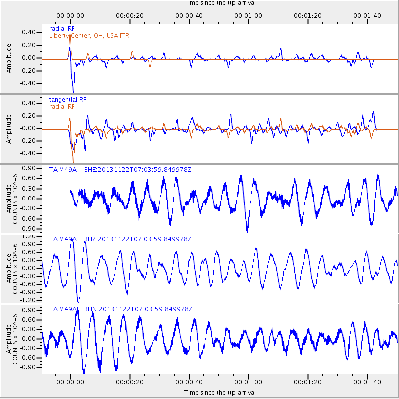
M49A Liberty Center, OH, USA - Earthquake Result Viewer
*The percent match for this event was below the threshold and hence no stack was calculated.
| Earthquake location: |
Iran-Iraq Border Region |
| Earthquake latitude/longitude: |
34.5/45.5 |
| Earthquake time(UTC): |
2013/11/22 (326) 06:51:25 GMT |
| Earthquake Depth: |
6.0 km |
| Earthquake Magnitude: |
5.6 MWB, 5.7 MWC |
| Earthquake Catalog/Contributor: |
NEIC PDE/NEIC COMCAT |
|
| Network: |
TA USArray Transportable Network (new EarthScope stations) |
| Station: |
M49A Liberty Center, OH, USA |
| Lat/Lon: |
41.47 N/83.98 W |
| Elevation: |
203 m |
|
| Distance: |
91.3 deg |
| Az: |
324.525 deg |
| Baz: |
39.655 deg |
| Ray Param: |
$rayparam |
*The percent match for this event was below the threshold and hence was not used in the summary stack. |
|
| Radial Match: |
74.89663 % |
| Radial Bump: |
400 |
| Transverse Match: |
74.16306 % |
| Transverse Bump: |
400 |
| SOD ConfigId: |
626651 |
| Insert Time: |
2014-04-19 18:53:46.098 +0000 |
| GWidth: |
2.5 |
| Max Bumps: |
400 |
| Tol: |
0.001 |
|
Signal To Noise
| Channel | StoN | STA | LTA |
| TA:M49A: :BHZ:20131122T07:03:59.849978Z | 2.5273688 | 8.0800135E-7 | 3.197006E-7 |
| TA:M49A: :BHN:20131122T07:03:59.849978Z | 3.912568 | 6.157368E-7 | 1.5737407E-7 |
| TA:M49A: :BHE:20131122T07:03:59.849978Z | 2.0340023 | 4.1358658E-7 | 2.0333633E-7 |
| Arrivals |
| Ps | |
| PpPs | |
| PsPs/PpSs | |


