You are here: Home > Network List > IU - Global Seismograph Network (GSN - IRIS/USGS) Stations List
> Station PMG Port Moresby, New Guinea > Earthquake Result Viewer
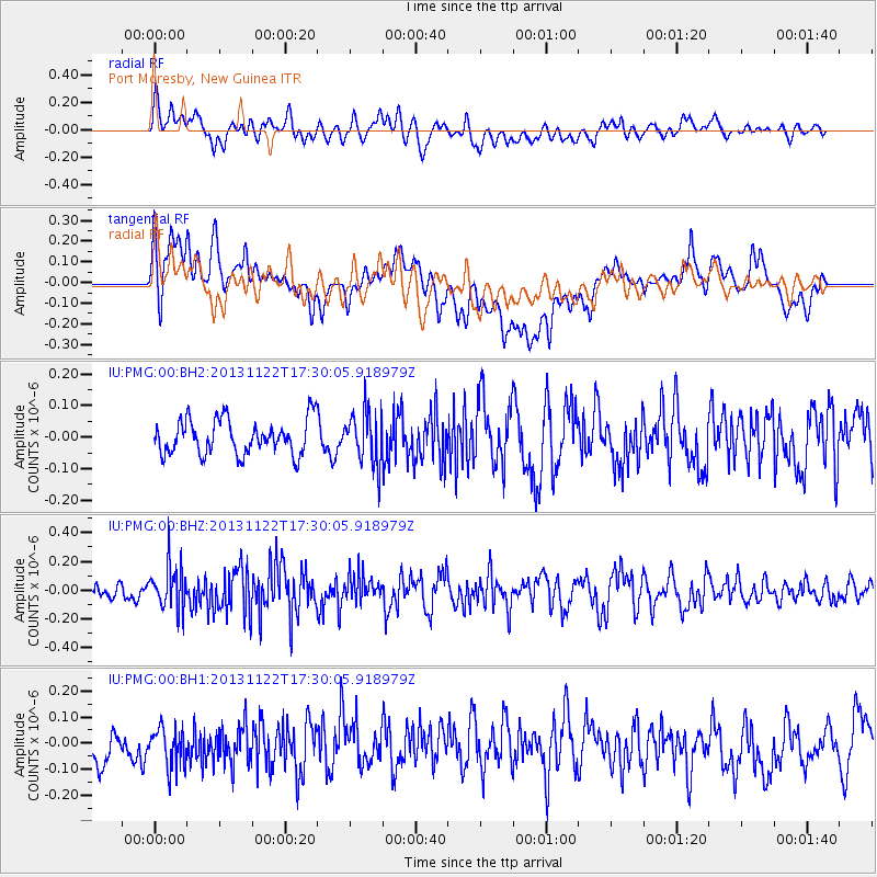
PMG Port Moresby, New Guinea - Earthquake Result Viewer
*The percent match for this event was below the threshold and hence no stack was calculated.
| Earthquake location: |
Off W Coast Of Northern Sumatra |
| Earthquake latitude/longitude: |
5.4/92.8 |
| Earthquake time(UTC): |
2013/11/22 (326) 17:20:58 GMT |
| Earthquake Depth: |
16 km |
| Earthquake Magnitude: |
5.5 MWW, 5.3 MWB, 5.5 MWC |
| Earthquake Catalog/Contributor: |
NEIC PDE/NEIC COMCAT |
|
| Network: |
IU Global Seismograph Network (GSN - IRIS/USGS) |
| Station: |
PMG Port Moresby, New Guinea |
| Lat/Lon: |
9.40 S/147.16 E |
| Elevation: |
90 m |
|
| Distance: |
56.1 deg |
| Az: |
105.053 deg |
| Baz: |
283.005 deg |
| Ray Param: |
$rayparam |
*The percent match for this event was below the threshold and hence was not used in the summary stack. |
|
| Radial Match: |
52.979137 % |
| Radial Bump: |
400 |
| Transverse Match: |
29.262768 % |
| Transverse Bump: |
400 |
| SOD ConfigId: |
626651 |
| Insert Time: |
2014-04-19 19:07:25.035 +0000 |
| GWidth: |
2.5 |
| Max Bumps: |
400 |
| Tol: |
0.001 |
|
Signal To Noise
| Channel | StoN | STA | LTA |
| IU:PMG:00:BHZ:20131122T17:30:05.918979Z | 3.1192436 | 1.5577825E-7 | 4.9941036E-8 |
| IU:PMG:00:BH1:20131122T17:30:05.918979Z | 0.9651705 | 1.0664905E-7 | 1.1049762E-7 |
| IU:PMG:00:BH2:20131122T17:30:05.918979Z | 1.5114957 | 8.382097E-8 | 5.5455647E-8 |
| Arrivals |
| Ps | |
| PpPs | |
| PsPs/PpSs | |


