You are here: Home > Network List > TA - USArray Transportable Network (new EarthScope stations) Stations List
> Station T57A Hurt, VA, USA > Earthquake Result Viewer
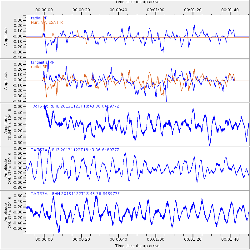
T57A Hurt, VA, USA - Earthquake Result Viewer
*The percent match for this event was below the threshold and hence no stack was calculated.
| Earthquake location: |
Iran-Iraq Border Region |
| Earthquake latitude/longitude: |
34.3/45.6 |
| Earthquake time(UTC): |
2013/11/22 (326) 18:30:58 GMT |
| Earthquake Depth: |
14 km |
| Earthquake Magnitude: |
5.8 MWW, 5.6 MWB, 5.8 MWC |
| Earthquake Catalog/Contributor: |
NEIC PDE/NEIC COMCAT |
|
| Network: |
TA USArray Transportable Network (new EarthScope stations) |
| Station: |
T57A Hurt, VA, USA |
| Lat/Lon: |
37.00 N/79.25 W |
| Elevation: |
230 m |
|
| Distance: |
92.4 deg |
| Az: |
318.891 deg |
| Baz: |
42.829 deg |
| Ray Param: |
$rayparam |
*The percent match for this event was below the threshold and hence was not used in the summary stack. |
|
| Radial Match: |
78.339874 % |
| Radial Bump: |
400 |
| Transverse Match: |
60.063408 % |
| Transverse Bump: |
400 |
| SOD ConfigId: |
626651 |
| Insert Time: |
2014-04-19 19:27:50.491 +0000 |
| GWidth: |
2.5 |
| Max Bumps: |
400 |
| Tol: |
0.001 |
|
Signal To Noise
| Channel | StoN | STA | LTA |
| TA:T57A: :BHZ:20131122T18:43:36.648977Z | 2.4402149 | 5.0411523E-7 | 2.0658644E-7 |
| TA:T57A: :BHN:20131122T18:43:36.648977Z | 0.9028356 | 2.256552E-7 | 2.499405E-7 |
| TA:T57A: :BHE:20131122T18:43:36.648977Z | 1.2192429 | 2.4282778E-7 | 1.9916276E-7 |
| Arrivals |
| Ps | |
| PpPs | |
| PsPs/PpSs | |


