You are here: Home > Network List > TA - USArray Transportable Network (new EarthScope stations) Stations List
> Station U57A Blanch, NC, USA > Earthquake Result Viewer
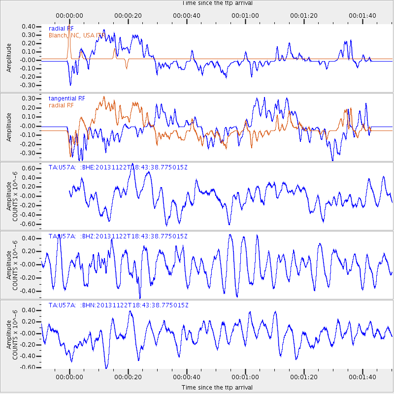
U57A Blanch, NC, USA - Earthquake Result Viewer
*The percent match for this event was below the threshold and hence no stack was calculated.
| Earthquake location: |
Iran-Iraq Border Region |
| Earthquake latitude/longitude: |
34.3/45.6 |
| Earthquake time(UTC): |
2013/11/22 (326) 18:30:58 GMT |
| Earthquake Depth: |
14 km |
| Earthquake Magnitude: |
5.8 MWW, 5.6 MWB, 5.8 MWC |
| Earthquake Catalog/Contributor: |
NEIC PDE/NEIC COMCAT |
|
| Network: |
TA USArray Transportable Network (new EarthScope stations) |
| Station: |
U57A Blanch, NC, USA |
| Lat/Lon: |
36.43 N/79.34 W |
| Elevation: |
178 m |
|
| Distance: |
92.9 deg |
| Az: |
318.556 deg |
| Baz: |
42.795 deg |
| Ray Param: |
$rayparam |
*The percent match for this event was below the threshold and hence was not used in the summary stack. |
|
| Radial Match: |
39.123337 % |
| Radial Bump: |
400 |
| Transverse Match: |
48.17251 % |
| Transverse Bump: |
400 |
| SOD ConfigId: |
626651 |
| Insert Time: |
2014-04-19 19:28:06.223 +0000 |
| GWidth: |
2.5 |
| Max Bumps: |
400 |
| Tol: |
0.001 |
|
Signal To Noise
| Channel | StoN | STA | LTA |
| TA:U57A: :BHZ:20131122T18:43:38.775015Z | 0.61227834 | 1.1860081E-7 | 1.9370407E-7 |
| TA:U57A: :BHN:20131122T18:43:38.775015Z | 3.176372 | 5.737519E-7 | 1.806312E-7 |
| TA:U57A: :BHE:20131122T18:43:38.775015Z | 1.3533913 | 3.5858704E-7 | 2.6495445E-7 |
| Arrivals |
| Ps | |
| PpPs | |
| PsPs/PpSs | |


