You are here: Home > Network List > TA - USArray Transportable Network (new EarthScope stations) Stations List
> Station W56A Indian Trail, NC, USA > Earthquake Result Viewer
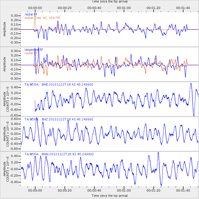
W56A Indian Trail, NC, USA - Earthquake Result Viewer
*The percent match for this event was below the threshold and hence no stack was calculated.
| Earthquake location: |
Iran-Iraq Border Region |
| Earthquake latitude/longitude: |
34.3/45.6 |
| Earthquake time(UTC): |
2013/11/22 (326) 18:30:58 GMT |
| Earthquake Depth: |
14 km |
| Earthquake Magnitude: |
5.8 MWW, 5.6 MWB, 5.8 MWC |
| Earthquake Catalog/Contributor: |
NEIC PDE/NEIC COMCAT |
|
| Network: |
TA USArray Transportable Network (new EarthScope stations) |
| Station: |
W56A Indian Trail, NC, USA |
| Lat/Lon: |
35.13 N/80.58 W |
| Elevation: |
177 m |
|
| Distance: |
94.5 deg |
| Az: |
318.43 deg |
| Baz: |
42.078 deg |
| Ray Param: |
$rayparam |
*The percent match for this event was below the threshold and hence was not used in the summary stack. |
|
| Radial Match: |
35.88836 % |
| Radial Bump: |
400 |
| Transverse Match: |
60.61097 % |
| Transverse Bump: |
400 |
| SOD ConfigId: |
626651 |
| Insert Time: |
2014-04-19 19:28:31.380 +0000 |
| GWidth: |
2.5 |
| Max Bumps: |
400 |
| Tol: |
0.001 |
|
Signal To Noise
| Channel | StoN | STA | LTA |
| TA:W56A: :BHZ:20131122T18:43:46.24999Z | 1.6475096 | 3.7140174E-7 | 2.2543222E-7 |
| TA:W56A: :BHN:20131122T18:43:46.24999Z | 1.5781863 | 2.9568133E-7 | 1.8735516E-7 |
| TA:W56A: :BHE:20131122T18:43:46.24999Z | 1.3584466 | 2.438341E-7 | 1.794948E-7 |
| Arrivals |
| Ps | |
| PpPs | |
| PsPs/PpSs | |


