You are here: Home > Network List > US - United States National Seismic Network Stations List
> Station EGMT Eagleton, Montana, USA > Earthquake Result Viewer
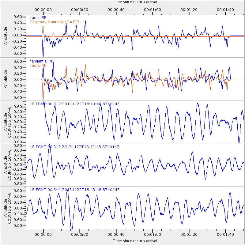
EGMT Eagleton, Montana, USA - Earthquake Result Viewer
*The percent match for this event was below the threshold and hence no stack was calculated.
| Earthquake location: |
Iran-Iraq Border Region |
| Earthquake latitude/longitude: |
34.3/45.6 |
| Earthquake time(UTC): |
2013/11/22 (326) 18:30:58 GMT |
| Earthquake Depth: |
14 km |
| Earthquake Magnitude: |
5.8 MWW, 5.6 MWB, 5.8 MWC |
| Earthquake Catalog/Contributor: |
NEIC PDE/NEIC COMCAT |
|
| Network: |
US United States National Seismic Network |
| Station: |
EGMT Eagleton, Montana, USA |
| Lat/Lon: |
48.02 N/109.75 W |
| Elevation: |
1055 m |
|
| Distance: |
95.1 deg |
| Az: |
343.684 deg |
| Baz: |
20.269 deg |
| Ray Param: |
$rayparam |
*The percent match for this event was below the threshold and hence was not used in the summary stack. |
|
| Radial Match: |
62.508625 % |
| Radial Bump: |
400 |
| Transverse Match: |
56.515606 % |
| Transverse Bump: |
400 |
| SOD ConfigId: |
626651 |
| Insert Time: |
2014-04-19 19:29:30.879 +0000 |
| GWidth: |
2.5 |
| Max Bumps: |
400 |
| Tol: |
0.001 |
|
Signal To Noise
| Channel | StoN | STA | LTA |
| US:EGMT:00:BHZ:20131122T18:43:48.874014Z | 2.8511038 | 4.407371E-7 | 1.5458473E-7 |
| US:EGMT:00:BH1:20131122T18:43:48.874014Z | 0.82857496 | 3.871128E-7 | 4.672031E-7 |
| US:EGMT:00:BH2:20131122T18:43:48.874014Z | 1.0727162 | 3.686975E-7 | 3.4370458E-7 |
| Arrivals |
| Ps | |
| PpPs | |
| PsPs/PpSs | |


