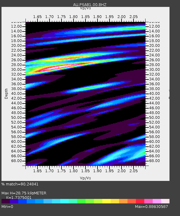
PSAB1 Pilbara Seismic Array Element B1 - Earthquake Result Viewer

Earthquake location: Fiji Islands Region
Earthquake latitude/longitude: -17.1/-176.5
Earthquake time(UTC): 2013/11/23 (327) 07:48:32 GMT
Earthquake Depth: 371 km
Earthquake Magnitude: 6.5 MWW, 6.4 MI, 6.5 MWC, 6.5 MWB
Earthquake Catalog/Contributor: NEIC PDE/NEIC COMCAT
Network: AU Australian Seismological Centre
Station: PSAB1 Pilbara Seismic Array Element B1
Lat/Lon: 21.57 S/119.82 E
Elevation: 317 m
Distance: 59.9 deg
Az: 254.673 deg
Baz: 97.781 deg
Ray Param: 0.06060284
Estimated Moho Depth: 28.75 km
Estimated Crust Vp/Vs: 1.74
Assumed Crust Vp: 6.464 km/s
Estimated Crust Vs: 3.72 km/s
Estimated Crust Poisson's Ratio: 0.25
Radial Match: 90.24841 %
Radial Bump: 326
Transverse Match: 67.19995 %
Transverse Bump: 400
SOD ConfigId: 626651
Insert Time: 2014-04-19 19:34:35.837 +0000
GWidth: 2.5
Max Bumps: 400
Tol: 0.001

Signal To Noise

ChannelStoNSTALTA
AU:PSAB1:00:BHZ:20131123T07:57:29.194026Z12.7970153.7002565E-62.8914997E-7
AU:PSAB1:00:BH1:20131123T07:57:29.194026Z11.2501851.7645539E-61.5684665E-7
AU:PSAB1:00:BH2:20131123T07:57:29.194026Z2.35483463.7305017E-71.5841884E-7
Arrivals
Ps3.4 SECOND
PpPs12 SECOND
PsPs/PpSs15 SECOND