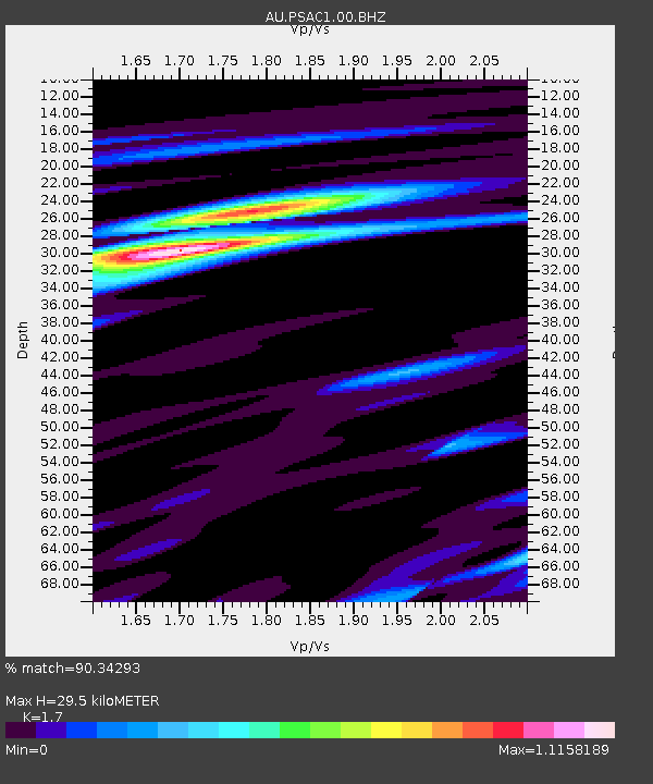
PSAC1 Pilbara Seismic Array Element C1 - Earthquake Result Viewer

Earthquake location: Fiji Islands Region
Earthquake latitude/longitude: -17.1/-176.5
Earthquake time(UTC): 2013/11/23 (327) 07:48:32 GMT
Earthquake Depth: 371 km
Earthquake Magnitude: 6.5 MWW, 6.4 MI, 6.5 MWC, 6.5 MWB
Earthquake Catalog/Contributor: NEIC PDE/NEIC COMCAT
Network: AU Australian Seismological Centre
Station: PSAC1 Pilbara Seismic Array Element C1
Lat/Lon: 21.53 S/119.81 E
Elevation: 303 m
Distance: 59.9 deg
Az: 254.711 deg
Baz: 97.804 deg
Ray Param: 0.06059279
Estimated Moho Depth: 29.5 km
Estimated Crust Vp/Vs: 1.70
Assumed Crust Vp: 6.464 km/s
Estimated Crust Vs: 3.802 km/s
Estimated Crust Poisson's Ratio: 0.24
Radial Match: 90.34293 %
Radial Bump: 285
Transverse Match: 60.52698 %
Transverse Bump: 400
SOD ConfigId: 626651
Insert Time: 2014-04-19 19:34:40.997 +0000
GWidth: 2.5
Max Bumps: 400
Tol: 0.001

Signal To Noise

ChannelStoNSTALTA
AU:PSAC1:00:BHZ:20131123T07:57:29.294001Z13.6681023.8761327E-62.8358966E-7
AU:PSAC1:00:BH1:20131123T07:57:29.294001Z2.5248143.4932984E-71.3835866E-7
AU:PSAC1:00:BH2:20131123T07:57:29.294001Z14.4965721.9917045E-61.3739142E-7
Arrivals
Ps3.4 SECOND
PpPs12 SECOND
PsPs/PpSs15 SECOND