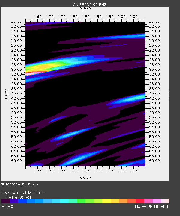
PSAD2 Pilbara Seismic Array Element D2 - Earthquake Result Viewer

Earthquake location: Fiji Islands Region
Earthquake latitude/longitude: -17.1/-176.5
Earthquake time(UTC): 2013/11/23 (327) 07:48:32 GMT
Earthquake Depth: 371 km
Earthquake Magnitude: 6.5 MWW, 6.4 MI, 6.5 MWC, 6.5 MWB
Earthquake Catalog/Contributor: NEIC PDE/NEIC COMCAT
Network: AU Australian Seismological Centre
Station: PSAD2 Pilbara Seismic Array Element D2
Lat/Lon: 21.62 S/119.96 E
Elevation: 366 m
Distance: 59.7 deg
Az: 254.638 deg
Baz: 97.712 deg
Ray Param: 0.060686618
Estimated Moho Depth: 31.5 km
Estimated Crust Vp/Vs: 1.62
Assumed Crust Vp: 6.464 km/s
Estimated Crust Vs: 3.984 km/s
Estimated Crust Poisson's Ratio: 0.19
Radial Match: 85.85664 %
Radial Bump: 320
Transverse Match: 75.54816 %
Transverse Bump: 400
SOD ConfigId: 626651
Insert Time: 2014-04-19 19:34:48.879 +0000
GWidth: 2.5
Max Bumps: 400
Tol: 0.001

Signal To Noise

ChannelStoNSTALTA
AU:PSAD2:00:BHZ:20131123T07:57:28.268977Z9.9626893.5218948E-63.5350843E-7
AU:PSAD2:00:BH1:20131123T07:57:28.268977Z8.5530011.7069896E-61.9957784E-7
AU:PSAD2:00:BH2:20131123T07:57:28.268977Z2.96951654.9723997E-71.6744812E-7
Arrivals
Ps3.2 SECOND
PpPs12 SECOND
PsPs/PpSs15 SECOND