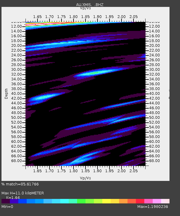
XMIS Christmas Island Grants Well - Earthquake Result Viewer

Earthquake location: Fiji Islands Region
Earthquake latitude/longitude: -17.1/-176.5
Earthquake time(UTC): 2013/11/23 (327) 07:48:32 GMT
Earthquake Depth: 371 km
Earthquake Magnitude: 6.5 MWW, 6.4 MI, 6.5 MWC, 6.5 MWB
Earthquake Catalog/Contributor: NEIC PDE/NEIC COMCAT
Network: AU Australian Seismological Centre
Station: XMIS Christmas Island Grants Well
Lat/Lon: 10.48 S/105.65 E
Elevation: 210 m
Distance: 75.4 deg
Az: 263.353 deg
Baz: 105.043 deg
Ray Param: 0.050602358
Estimated Moho Depth: 11.0 km
Estimated Crust Vp/Vs: 1.64
Assumed Crust Vp: 4.157 km/s
Estimated Crust Vs: 2.535 km/s
Estimated Crust Poisson's Ratio: 0.20
Radial Match: 85.61766 %
Radial Bump: 344
Transverse Match: 69.55135 %
Transverse Bump: 400
SOD ConfigId: 626651
Insert Time: 2014-04-19 19:35:05.696 +0000
GWidth: 2.5
Max Bumps: 400
Tol: 0.001

Signal To Noise

ChannelStoNSTALTA
AU:XMIS: :BHZ:20131123T07:59:05.194026Z28.6402654.457812E-61.5564841E-7
AU:XMIS: :BHN:20131123T07:59:05.194026Z3.2693796.4421465E-71.9704497E-7
AU:XMIS: :BHE:20131123T07:59:05.194026Z9.9396091.9262268E-61.9379303E-7
Arrivals
Ps1.7 SECOND
PpPs6.9 SECOND
PsPs/PpSs8.6 SECOND