You are here: Home > Network List > TA - USArray Transportable Network (new EarthScope stations) Stations List
> Station 121A Cookes Peak, Deming, NM, USA > Earthquake Result Viewer
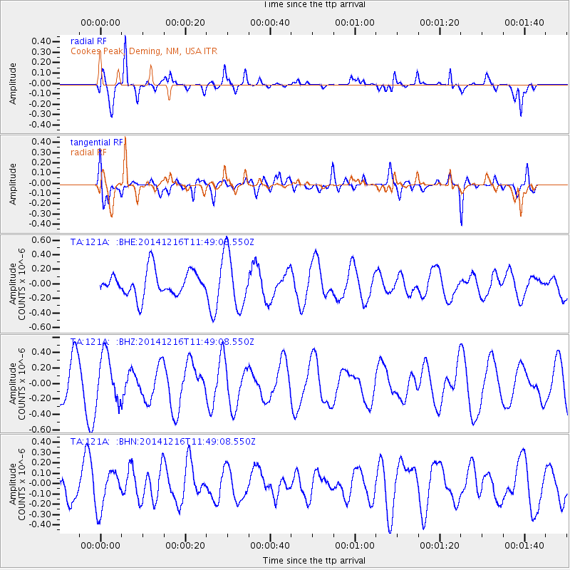
121A Cookes Peak, Deming, NM, USA - Earthquake Result Viewer
*The percent match for this event was below the threshold and hence no stack was calculated.
| Earthquake location: |
Santa Cruz Islands |
| Earthquake latitude/longitude: |
-10.9/166.0 |
| Earthquake time(UTC): |
2014/12/16 (350) 11:36:34 GMT |
| Earthquake Depth: |
56 km |
| Earthquake Magnitude: |
5.5 MW, 5.2 mb |
| Earthquake Catalog/Contributor: |
ISC/ISC |
|
| Network: |
TA USArray Transportable Network (new EarthScope stations) |
| Station: |
121A Cookes Peak, Deming, NM, USA |
| Lat/Lon: |
32.53 N/107.79 W |
| Elevation: |
1652 m |
|
| Distance: |
92.7 deg |
| Az: |
57.545 deg |
| Baz: |
258.852 deg |
| Ray Param: |
$rayparam |
*The percent match for this event was below the threshold and hence was not used in the summary stack. |
|
| Radial Match: |
77.11386 % |
| Radial Bump: |
318 |
| Transverse Match: |
63.574207 % |
| Transverse Bump: |
400 |
| SOD ConfigId: |
3390531 |
| Insert Time: |
2019-04-15 14:06:20.882 +0000 |
| GWidth: |
2.5 |
| Max Bumps: |
400 |
| Tol: |
0.001 |
|
Signal To Noise
| Channel | StoN | STA | LTA |
| TA:121A: :BHZ:20141216T11:49:08.550Z | 1.3872249 | 3.0619722E-7 | 2.2072645E-7 |
| TA:121A: :BHN:20141216T11:49:08.550Z | 1.1080934 | 1.861711E-7 | 1.680103E-7 |
| TA:121A: :BHE:20141216T11:49:08.550Z | 2.2729478 | 3.8508966E-7 | 1.69423E-7 |
| Arrivals |
| Ps | |
| PpPs | |
| PsPs/PpSs | |


