You are here: Home > Network List > TA - USArray Transportable Network (new EarthScope stations) Stations List
> Station G05D Wamic, OR, USA > Earthquake Result Viewer
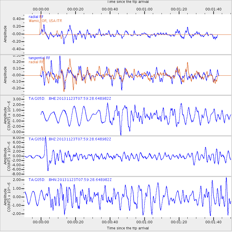
G05D Wamic, OR, USA - Earthquake Result Viewer
*The percent match for this event was below the threshold and hence no stack was calculated.
| Earthquake location: |
Fiji Islands Region |
| Earthquake latitude/longitude: |
-17.1/-176.5 |
| Earthquake time(UTC): |
2013/11/23 (327) 07:48:32 GMT |
| Earthquake Depth: |
371 km |
| Earthquake Magnitude: |
6.5 MWW, 6.4 MI, 6.5 MWC, 6.5 MWB |
| Earthquake Catalog/Contributor: |
NEIC PDE/NEIC COMCAT |
|
| Network: |
TA USArray Transportable Network (new EarthScope stations) |
| Station: |
G05D Wamic, OR, USA |
| Lat/Lon: |
45.24 N/121.32 W |
| Elevation: |
592 m |
|
| Distance: |
79.7 deg |
| Az: |
36.141 deg |
| Baz: |
232.967 deg |
| Ray Param: |
$rayparam |
*The percent match for this event was below the threshold and hence was not used in the summary stack. |
|
| Radial Match: |
64.20221 % |
| Radial Bump: |
400 |
| Transverse Match: |
70.12428 % |
| Transverse Bump: |
389 |
| SOD ConfigId: |
626651 |
| Insert Time: |
2014-04-19 19:49:22.632 +0000 |
| GWidth: |
2.5 |
| Max Bumps: |
400 |
| Tol: |
0.001 |
|
Signal To Noise
| Channel | StoN | STA | LTA |
| TA:G05D: :BHZ:20131123T07:59:28.648982Z | 14.607641 | 3.624133E-6 | 2.4809842E-7 |
| TA:G05D: :BHN:20131123T07:59:28.648982Z | 1.4750004 | 5.5038925E-7 | 3.7314516E-7 |
| TA:G05D: :BHE:20131123T07:59:28.648982Z | 0.6299304 | 6.023506E-7 | 9.562178E-7 |
| Arrivals |
| Ps | |
| PpPs | |
| PsPs/PpSs | |


