You are here: Home > Network List > TA - USArray Transportable Network (new EarthScope stations) Stations List
> Station MDND Maddock, ND, USA > Earthquake Result Viewer
MDND Maddock, ND, USA - Earthquake Result Viewer
*The percent match for this event was below the threshold and hence no stack was calculated.
| Earthquake location: |
Fiji Islands Region |
| Earthquake latitude/longitude: |
-17.1/-176.5 |
| Earthquake time(UTC): |
2013/11/23 (327) 07:48:32 GMT |
| Earthquake Depth: |
371 km |
| Earthquake Magnitude: |
6.5 MWW, 6.4 MI, 6.5 MWC, 6.5 MWB |
| Earthquake Catalog/Contributor: |
NEIC PDE/NEIC COMCAT |
|
| Network: |
TA USArray Transportable Network (new EarthScope stations) |
| Station: |
MDND Maddock, ND, USA |
| Lat/Lon: |
47.85 N/99.60 W |
| Elevation: |
479 m |
|
| Distance: |
94.1 deg |
| Az: |
41.132 deg |
| Baz: |
249.046 deg |
| Ray Param: |
$rayparam |
*The percent match for this event was below the threshold and hence was not used in the summary stack. |
|
| Radial Match: |
56.832848 % |
| Radial Bump: |
383 |
| Transverse Match: |
57.32249 % |
| Transverse Bump: |
367 |
| SOD ConfigId: |
626651 |
| Insert Time: |
2014-04-19 19:50:16.209 +0000 |
| GWidth: |
2.5 |
| Max Bumps: |
400 |
| Tol: |
0.001 |
|
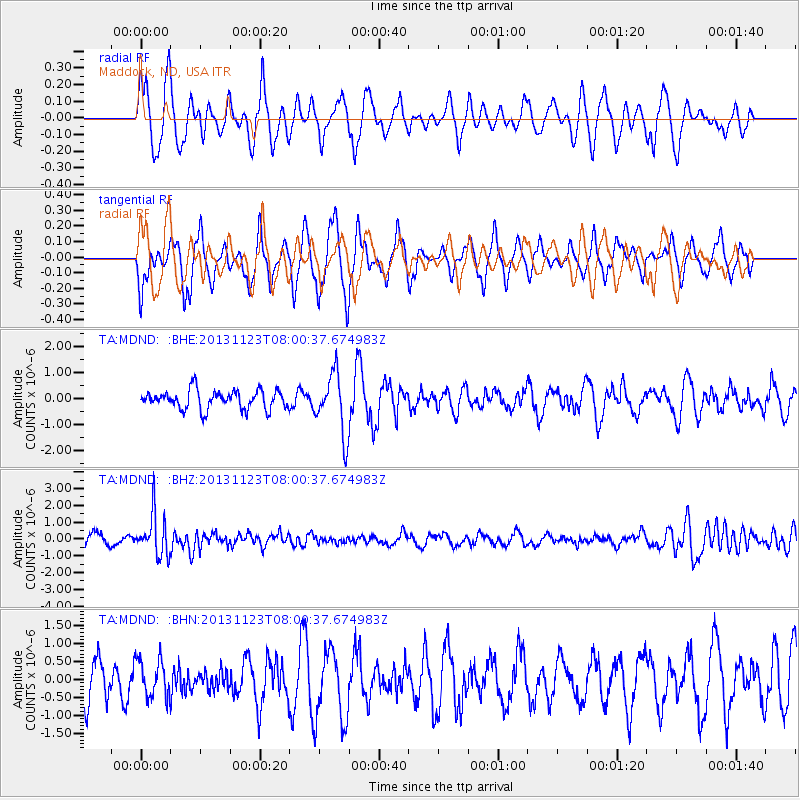
Signal To Noise
| Channel | StoN | STA | LTA |
| TA:MDND: :BHZ:20131123T08:00:37.674983Z | 4.1485257 | 1.2442894E-6 | 2.9993532E-7 |
| TA:MDND: :BHN:20131123T08:00:37.674983Z | 1.0982435 | 5.1497443E-7 | 4.6890736E-7 |
| TA:MDND: :BHE:20131123T08:00:37.674983Z | 3.2030783 | 1.1718223E-6 | 3.6584257E-7 |
| Arrivals |
| Ps | |
| PpPs | |
| PsPs/PpSs | |


