You are here: Home > Network List > TA - USArray Transportable Network (new EarthScope stations) Stations List
> Station MSTX Muleshoe, TX, USA > Earthquake Result Viewer
MSTX Muleshoe, TX, USA - Earthquake Result Viewer

| Earthquake location: |
Fiji Islands Region |
| Earthquake latitude/longitude: |
-17.1/-176.5 |
| Earthquake time(UTC): |
2013/11/23 (327) 07:48:32 GMT |
| Earthquake Depth: |
371 km |
| Earthquake Magnitude: |
6.5 MWW, 6.4 MI, 6.5 MWC, 6.5 MWB |
| Earthquake Catalog/Contributor: |
NEIC PDE/NEIC COMCAT |
|
| Network: |
TA USArray Transportable Network (new EarthScope stations) |
| Station: |
MSTX Muleshoe, TX, USA |
| Lat/Lon: |
33.97 N/102.77 W |
| Elevation: |
1167 m |
|
| Distance: |
86.6 deg |
| Az: |
53.07 deg |
| Baz: |
246.895 deg |
| Ray Param: |
0.042982105 |
| Estimated Moho Depth: |
42.75 km |
| Estimated Crust Vp/Vs: |
1.81 |
| Assumed Crust Vp: |
6.129 km/s |
| Estimated Crust Vs: |
3.391 km/s |
| Estimated Crust Poisson's Ratio: |
0.28 |
|
| Radial Match: |
89.390564 % |
| Radial Bump: |
257 |
| Transverse Match: |
74.127884 % |
| Transverse Bump: |
361 |
| SOD ConfigId: |
626651 |
| Insert Time: |
2014-04-19 19:50:20.975 +0000 |
| GWidth: |
2.5 |
| Max Bumps: |
400 |
| Tol: |
0.001 |
|
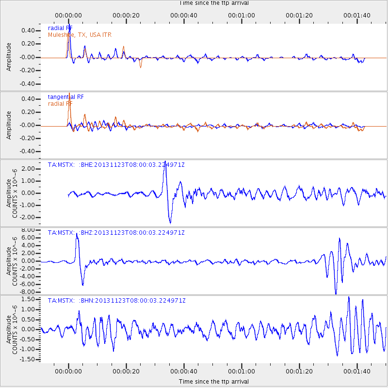
Signal To Noise
| Channel | StoN | STA | LTA |
| TA:MSTX: :BHZ:20131123T08:00:03.224971Z | 20.56767 | 3.083868E-6 | 1.4993765E-7 |
| TA:MSTX: :BHN:20131123T08:00:03.224971Z | 3.0120015 | 3.3601106E-7 | 1.1155739E-7 |
| TA:MSTX: :BHE:20131123T08:00:03.224971Z | 10.176652 | 1.085154E-6 | 1.0663173E-7 |
| Arrivals |
| Ps | 5.7 SECOND |
| PpPs | 19 SECOND |
| PsPs/PpSs | 25 SECOND |


