You are here: Home > Network List > TA - USArray Transportable Network (new EarthScope stations) Stations List
> Station O02D Mt. Diablo Meridian, CA, USA > Earthquake Result Viewer
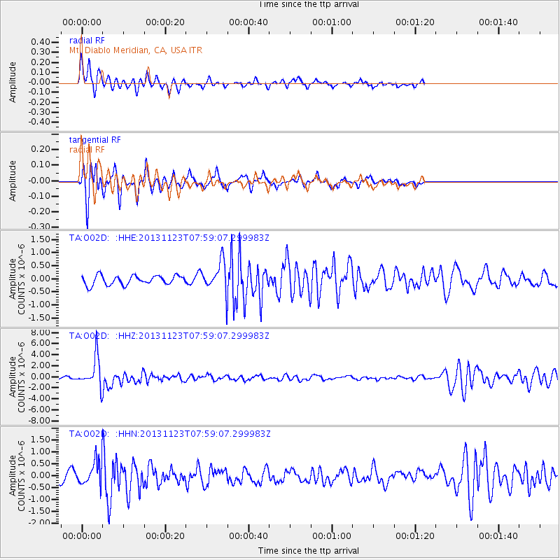
O02D Mt. Diablo Meridian, CA, USA - Earthquake Result Viewer
*The percent match for this event was below the threshold and hence no stack was calculated.
| Earthquake location: |
Fiji Islands Region |
| Earthquake latitude/longitude: |
-17.1/-176.5 |
| Earthquake time(UTC): |
2013/11/23 (327) 07:48:32 GMT |
| Earthquake Depth: |
371 km |
| Earthquake Magnitude: |
6.5 MWW, 6.4 MI, 6.5 MWC, 6.5 MWB |
| Earthquake Catalog/Contributor: |
NEIC PDE/NEIC COMCAT |
|
| Network: |
TA USArray Transportable Network (new EarthScope stations) |
| Station: |
O02D Mt. Diablo Meridian, CA, USA |
| Lat/Lon: |
40.18 N/122.79 W |
| Elevation: |
965 m |
|
| Distance: |
75.8 deg |
| Az: |
39.598 deg |
| Baz: |
232.704 deg |
| Ray Param: |
$rayparam |
*The percent match for this event was below the threshold and hence was not used in the summary stack. |
|
| Radial Match: |
79.39232 % |
| Radial Bump: |
285 |
| Transverse Match: |
81.02975 % |
| Transverse Bump: |
369 |
| SOD ConfigId: |
626651 |
| Insert Time: |
2014-04-19 19:50:28.314 +0000 |
| GWidth: |
2.5 |
| Max Bumps: |
400 |
| Tol: |
0.001 |
|
Signal To Noise
| Channel | StoN | STA | LTA |
| TA:O02D: :HHZ:20131123T07:59:07.299983Z | 13.913524 | 2.8018928E-6 | 2.013791E-7 |
| TA:O02D: :HHN:20131123T07:59:07.299983Z | 3.103467 | 5.001374E-7 | 1.611544E-7 |
| TA:O02D: :HHE:20131123T07:59:07.299983Z | 3.2552116 | 5.712236E-7 | 1.7547973E-7 |
| Arrivals |
| Ps | |
| PpPs | |
| PsPs/PpSs | |


