You are here: Home > Network List > TA - USArray Transportable Network (new EarthScope stations) Stations List
> Station O03E Paynes Creek, CA, USA > Earthquake Result Viewer
O03E Paynes Creek, CA, USA - Earthquake Result Viewer
| Earthquake location: |
Fiji Islands Region |
| Earthquake latitude/longitude: |
-17.1/-176.5 |
| Earthquake time(UTC): |
2013/11/23 (327) 07:48:32 GMT |
| Earthquake Depth: |
371 km |
| Earthquake Magnitude: |
6.5 MWW, 6.4 MI, 6.5 MWC, 6.5 MWB |
| Earthquake Catalog/Contributor: |
NEIC PDE/NEIC COMCAT |
|
| Network: |
TA USArray Transportable Network (new EarthScope stations) |
| Station: |
O03E Paynes Creek, CA, USA |
| Lat/Lon: |
40.29 N/121.80 W |
| Elevation: |
967 m |
|
| Distance: |
76.5 deg |
| Az: |
39.968 deg |
| Baz: |
233.427 deg |
| Ray Param: |
0.04990799 |
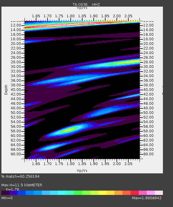
| Estimated Moho Depth: |
11.5 km |
| Estimated Crust Vp/Vs: |
1.78 |
| Assumed Crust Vp: |
6.566 km/s |
| Estimated Crust Vs: |
3.689 km/s |
| Estimated Crust Poisson's Ratio: |
0.27 |
|
| Radial Match: |
80.258194 % |
| Radial Bump: |
389 |
| Transverse Match: |
73.090485 % |
| Transverse Bump: |
400 |
| SOD ConfigId: |
626651 |
| Insert Time: |
2014-04-19 19:50:32.384 +0000 |
| GWidth: |
2.5 |
| Max Bumps: |
400 |
| Tol: |
0.001 |
|
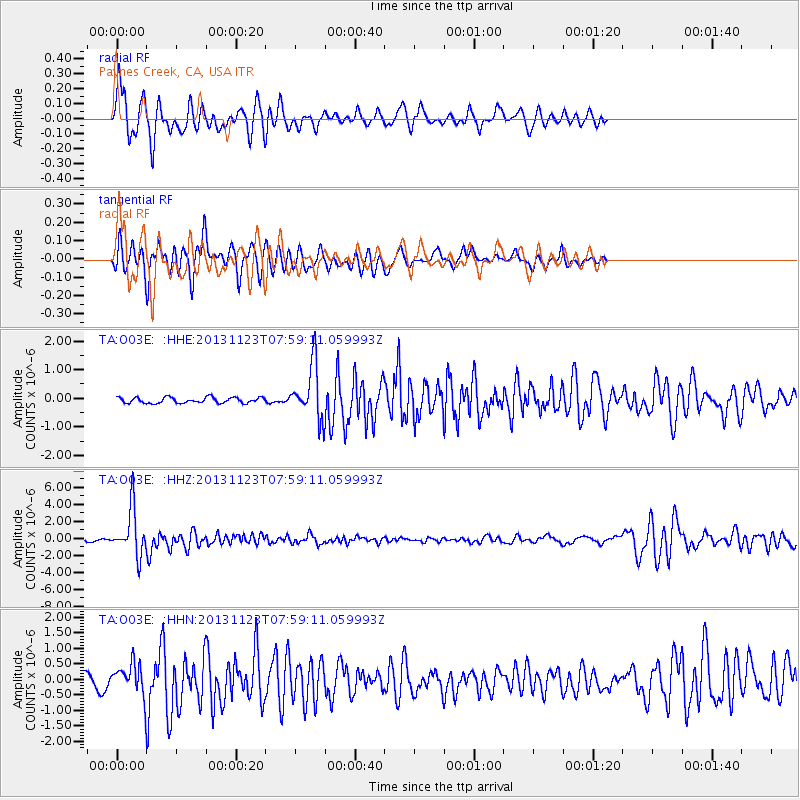
Signal To Noise
| Channel | StoN | STA | LTA |
| TA:O03E: :HHZ:20131123T07:59:11.059993Z | 21.725773 | 2.7748629E-6 | 1.2772217E-7 |
| TA:O03E: :HHN:20131123T07:59:11.059993Z | 2.985688 | 4.5164177E-7 | 1.512689E-7 |
| TA:O03E: :HHE:20131123T07:59:11.059993Z | 9.369221 | 9.3561334E-7 | 9.9860316E-8 |
| Arrivals |
| Ps | 1.4 SECOND |
| PpPs | 4.7 SECOND |
| PsPs/PpSs | 6.1 SECOND |


