You are here: Home > Network List > US - United States National Seismic Network Stations List
> Station MIAR Mount Ida, Arkansas, USA > Earthquake Result Viewer
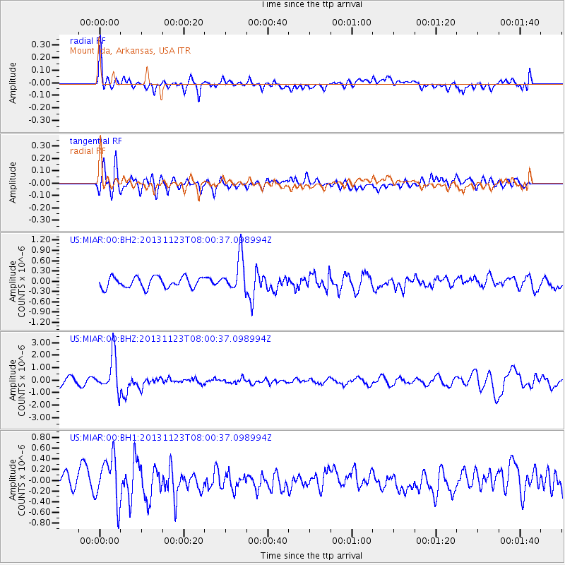
MIAR Mount Ida, Arkansas, USA - Earthquake Result Viewer
*The percent match for this event was below the threshold and hence no stack was calculated.
| Earthquake location: |
Fiji Islands Region |
| Earthquake latitude/longitude: |
-17.1/-176.5 |
| Earthquake time(UTC): |
2013/11/23 (327) 07:48:32 GMT |
| Earthquake Depth: |
371 km |
| Earthquake Magnitude: |
6.5 MWW, 6.4 MI, 6.5 MWC, 6.5 MWB |
| Earthquake Catalog/Contributor: |
NEIC PDE/NEIC COMCAT |
|
| Network: |
US United States National Seismic Network |
| Station: |
MIAR Mount Ida, Arkansas, USA |
| Lat/Lon: |
34.55 N/93.58 W |
| Elevation: |
207 m |
|
| Distance: |
93.9 deg |
| Az: |
55.202 deg |
| Baz: |
252.045 deg |
| Ray Param: |
$rayparam |
*The percent match for this event was below the threshold and hence was not used in the summary stack. |
|
| Radial Match: |
68.90167 % |
| Radial Bump: |
400 |
| Transverse Match: |
59.12743 % |
| Transverse Bump: |
400 |
| SOD ConfigId: |
626651 |
| Insert Time: |
2014-04-19 19:52:24.737 +0000 |
| GWidth: |
2.5 |
| Max Bumps: |
400 |
| Tol: |
0.001 |
|
Signal To Noise
| Channel | StoN | STA | LTA |
| US:MIAR:00:BHZ:20131123T08:00:37.098994Z | 5.923766 | 1.4668541E-6 | 2.4762187E-7 |
| US:MIAR:00:BH1:20131123T08:00:37.098994Z | 3.3873994 | 4.392447E-7 | 1.2967018E-7 |
| US:MIAR:00:BH2:20131123T08:00:37.098994Z | 3.3666232 | 5.301637E-7 | 1.574764E-7 |
| Arrivals |
| Ps | |
| PpPs | |
| PsPs/PpSs | |


