You are here: Home > Network List > UU - University of Utah Regional Network Stations List
> Station MTPU Mt. Pierson, UT, USA > Earthquake Result Viewer
MTPU Mt. Pierson, UT, USA - Earthquake Result Viewer
| Earthquake location: |
Fiji Islands Region |
| Earthquake latitude/longitude: |
-17.1/-176.5 |
| Earthquake time(UTC): |
2013/11/23 (327) 07:48:32 GMT |
| Earthquake Depth: |
371 km |
| Earthquake Magnitude: |
6.5 MWW, 6.4 MI, 6.5 MWC, 6.5 MWB |
| Earthquake Catalog/Contributor: |
NEIC PDE/NEIC COMCAT |
|
| Network: |
UU University of Utah Regional Network |
| Station: |
MTPU Mt. Pierson, UT, USA |
| Lat/Lon: |
38.04 N/112.18 W |
| Elevation: |
3112 m |
|
| Distance: |
81.5 deg |
| Az: |
46.027 deg |
| Baz: |
240.644 deg |
| Ray Param: |
0.046515096 |
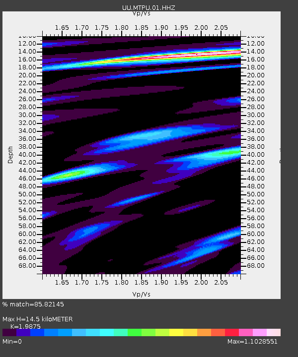
| Estimated Moho Depth: |
14.5 km |
| Estimated Crust Vp/Vs: |
1.99 |
| Assumed Crust Vp: |
6.276 km/s |
| Estimated Crust Vs: |
3.158 km/s |
| Estimated Crust Poisson's Ratio: |
0.33 |
|
| Radial Match: |
85.82145 % |
| Radial Bump: |
342 |
| Transverse Match: |
72.67802 % |
| Transverse Bump: |
342 |
| SOD ConfigId: |
626651 |
| Insert Time: |
2014-04-19 19:53:31.363 +0000 |
| GWidth: |
2.5 |
| Max Bumps: |
400 |
| Tol: |
0.001 |
|

Signal To Noise
| Channel | StoN | STA | LTA |
| UU:MTPU:01:HHZ:20131123T07:59:38.077998Z | 32.84981 | 9.736043E-8 | 2.9638045E-9 |
| UU:MTPU:01:HHN:20131123T07:59:38.077998Z | 3.8746855 | 1.3954201E-8 | 3.6013768E-9 |
| UU:MTPU:01:HHE:20131123T07:59:38.077998Z | 5.1485195 | 2.5081151E-8 | 4.8715267E-9 |
| Arrivals |
| Ps | 2.3 SECOND |
| PpPs | 6.8 SECOND |
| PsPs/PpSs | 9.1 SECOND |


