You are here: Home > Network List > WY - Yellowstone Wyoming Seismic Network Stations List
> Station YMR Madison River, YNP, WY, USA > Earthquake Result Viewer
YMR Madison River, YNP, WY, USA - Earthquake Result Viewer
| Earthquake location: |
Fiji Islands Region |
| Earthquake latitude/longitude: |
-17.1/-176.5 |
| Earthquake time(UTC): |
2013/11/23 (327) 07:48:32 GMT |
| Earthquake Depth: |
371 km |
| Earthquake Magnitude: |
6.5 MWW, 6.4 MI, 6.5 MWC, 6.5 MWB |
| Earthquake Catalog/Contributor: |
NEIC PDE/NEIC COMCAT |
|
| Network: |
WY Yellowstone Wyoming Seismic Network |
| Station: |
YMR Madison River, YNP, WY, USA |
| Lat/Lon: |
44.67 N/110.96 W |
| Elevation: |
2149 m |
|
| Distance: |
85.6 deg |
| Az: |
40.666 deg |
| Baz: |
240.846 deg |
| Ray Param: |
0.043705806 |
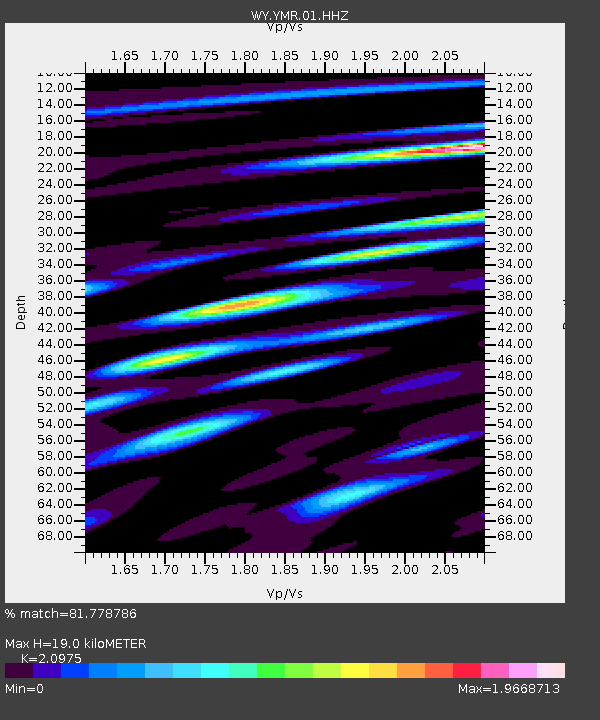
| Estimated Moho Depth: |
19.0 km |
| Estimated Crust Vp/Vs: |
2.10 |
| Assumed Crust Vp: |
6.35 km/s |
| Estimated Crust Vs: |
3.027 km/s |
| Estimated Crust Poisson's Ratio: |
0.35 |
|
| Radial Match: |
81.778786 % |
| Radial Bump: |
387 |
| Transverse Match: |
68.81024 % |
| Transverse Bump: |
389 |
| SOD ConfigId: |
626651 |
| Insert Time: |
2014-04-19 19:55:26.754 +0000 |
| GWidth: |
2.5 |
| Max Bumps: |
400 |
| Tol: |
0.001 |
|

Signal To Noise
| Channel | StoN | STA | LTA |
| WY:YMR:01:HHZ:20131123T07:59:58.29803Z | 10.711782 | 7.3020765E-8 | 6.816864E-9 |
| WY:YMR:01:HHN:20131123T07:59:58.29803Z | 1.6281755 | 1.7011628E-8 | 1.0448277E-8 |
| WY:YMR:01:HHE:20131123T07:59:58.29803Z | 2.739458 | 2.6188385E-8 | 9.559695E-9 |
| Arrivals |
| Ps | 3.3 SECOND |
| PpPs | 9.1 SECOND |
| PsPs/PpSs | 12 SECOND |


