You are here: Home > Network List > CB - China National Seismic Network Stations List
> Station HHC Huhehaote,Neimeng Province > Earthquake Result Viewer
HHC Huhehaote,Neimeng Province - Earthquake Result Viewer
| Earthquake location: |
Southern Sumatra, Indonesia |
| Earthquake latitude/longitude: |
-3.9/100.1 |
| Earthquake time(UTC): |
2014/12/17 (351) 06:10:05 GMT |
| Earthquake Depth: |
10 km |
| Earthquake Magnitude: |
5.6 MB |
| Earthquake Catalog/Contributor: |
NEIC PDE/NEIC COMCAT |
|
| Network: |
CB China National Seismic Network |
| Station: |
HHC Huhehaote,Neimeng Province |
| Lat/Lon: |
40.85 N/111.56 E |
| Elevation: |
1169 m |
|
| Distance: |
45.8 deg |
| Az: |
12.115 deg |
| Baz: |
196.023 deg |
| Ray Param: |
0.07105178 |
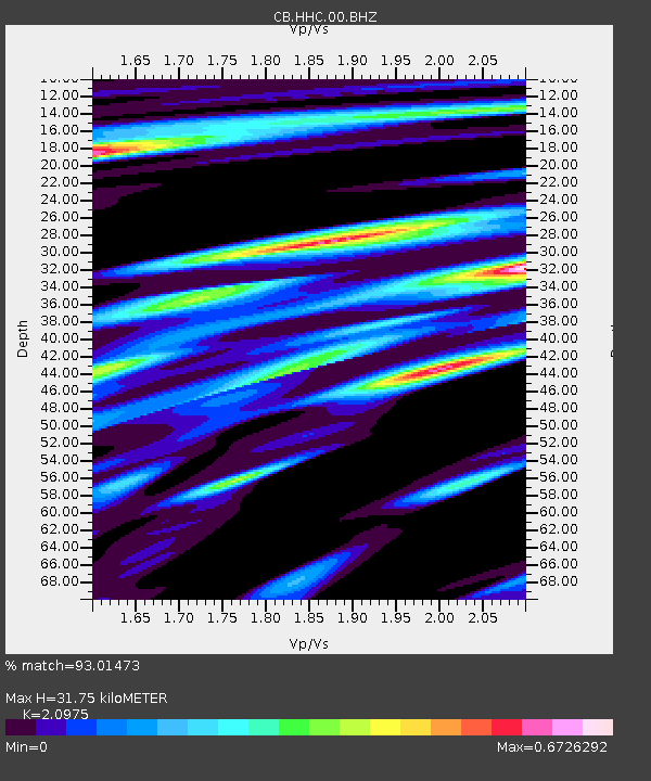
| Estimated Moho Depth: |
31.75 km |
| Estimated Crust Vp/Vs: |
2.10 |
| Assumed Crust Vp: |
6.384 km/s |
| Estimated Crust Vs: |
3.044 km/s |
| Estimated Crust Poisson's Ratio: |
0.35 |
|
| Radial Match: |
93.01473 % |
| Radial Bump: |
249 |
| Transverse Match: |
86.453415 % |
| Transverse Bump: |
400 |
| SOD ConfigId: |
3390531 |
| Insert Time: |
2019-04-15 14:15:20.210 +0000 |
| GWidth: |
2.5 |
| Max Bumps: |
400 |
| Tol: |
0.001 |
|

Signal To Noise
| Channel | StoN | STA | LTA |
| CB:HHC:00:BHZ:20141217T06:17:55.62001Z | 13.967175 | 2.531643E-6 | 1.8125664E-7 |
| CB:HHC:00:BHN:20141217T06:17:55.62001Z | 7.157152 | 1.2430565E-6 | 1.7368032E-7 |
| CB:HHC:00:BHE:20141217T06:17:55.62001Z | 2.20357 | 4.5500798E-7 | 2.0648673E-7 |
| Arrivals |
| Ps | 5.8 SECOND |
| PpPs | 15 SECOND |
| PsPs/PpSs | 20 SECOND |


